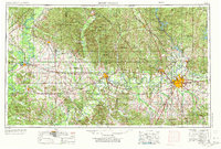
1953 Map of Montgomery
USGS Topo · Published 1973About this map
Montgomery serves as the focal point of this regional study, which captures Central Alabama during a period of mid-century infrastructure growth. The capital city is anchored by the State Capitol and surrounded by a dense network of military installations including Maxwell AFB and Gunter AFB. The landscape is defined by the winding course of the Alabama River, which connects major hubs like Selma and Prattville while carving out distinctive geographic features such as Gees Bend and Canton Bend.
Find a feature on this map
102 named features on this map. Tap any name to fly to it.
Don’t see what you’re looking for? This feature index may not catch every label — zoom into the map to look around manually.
Map Details
Editions of this 1953 Montgomery Map
4 editions found

Other maps of this area

1890 · Bessemer
USGS Topo · 1:125,000

1890 · Talladega
USGS Topo · 1:125,000

1891 · Clanton
USGS Topo · 1:125,000

1891 · Ashland
USGS Topo · 1:125,000

1892 · Talladega
USGS Topo · 1:125,000

1892 · Bessemer
USGS Topo · 1:125,000

1899 · Brookwood
USGS Topo · 1:125,000

1901 · Wetumpka
USGS Topo · 1:125,000

1901 · Wetumpka
USGS Topo · 1:62,500

1903 · Wetumpka
USGS Topo · 1:125,000