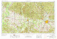
1953 Map of Montgomery
USGS Topo · Published 1978About this map
The Alabama River winds through the heart of the Black Belt in this mid-century survey, anchoring the historic centers of Montgomery and Selma. The landscape is defined by the convergence of major waterways, including the Cahaba River and Coosa River, which once served as the primary arteries of commerce before the rise of the extensive rail network shown here. The map reveals a post-war era of significant military activity, with Maxwell AFB, Gunter AFB, and Craig AFB established as permanent fixtures near the urban centers. To the north, the Talladega National Forest encompasses the high ground of the Appalachian foothills, including Bald Knob and Flag Mountain. This era captures the transition from a river-and-rail economy to a modern highway-centric one, evidenced by the primary routes of U.S. Highway 80 and U.S. Highway 31 connecting rural settlements like Uniontown and Marion.
Find a feature on this map
263 named features on this map. Tap any name to fly to it.
Don’t see what you’re looking for? This feature index may not catch every label — zoom into the map to look around manually.
Map Details
Editions of this 1953 Montgomery Map
4 editions found

Other maps of this area

1890 · Bessemer
USGS Topo · 1:125,000

1890 · Talladega
USGS Topo · 1:125,000

1891 · Clanton
USGS Topo · 1:125,000

1891 · Ashland
USGS Topo · 1:125,000

1892 · Talladega
USGS Topo · 1:125,000

1892 · Bessemer
USGS Topo · 1:125,000

1899 · Brookwood
USGS Topo · 1:125,000

1901 · Wetumpka
USGS Topo · 1:125,000

1901 · Wetumpka
USGS Topo · 1:62,500

1903 · Wetumpka
USGS Topo · 1:125,000