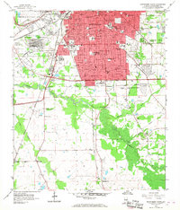
1958 Map of Montgomery South
USGS Topo · Published 1968About this map
The southern expansion of Montgomery dominates the northern half of this mid-century survey, revealing a landscape transitioning from the urban core toward the agricultural plains. Significant educational and religious centers like Huntingdon College and the St Jude Institution anchor the residential developments, while the presence of Alabama State College and Alabama Christian College underscores the city's role as an academic hub. To the west, the Maxwell Air Force Base Military Reservation marks a large footprint near the Mobile and Ohio Railroad.
Find a feature on this map
71 named features on this map. Tap any name to fly to it.
Don’t see what you’re looking for? This feature index may not catch every label — zoom into the map to look around manually.
Map Details
Editions of this 1958 Montgomery South Map
5 editions found
Other maps of this area

1927 · Montgomery
USGS Topo · 1:48,000

1930 · Montgomery
USGS Topo · 1:62,500

1953 · Montgomery
USGS Topo · 1:250,000

1956 · Montgomery
USGS Topo · 1:250,000

1957 · Montgomery
USGS Topo · 1:250,000

1957 · Letohatchee
USGS Topo · 1:62,500

1958 · Montgomery
USGS Topo · 1:62,500

1958 · Montgomery North
USGS Topo · 1:24,000

1958 · Montgomery South
USGS Topo · 1:24,000

1958 · Mount Meigs
USGS Topo · 1:62,500
Featured Places
- Montgomery, AL
- Perry Hills, Montgomery
- Cleveland Meadows, Montgomery
- Windwood, Montgomery
- Mayfair, Montgomery