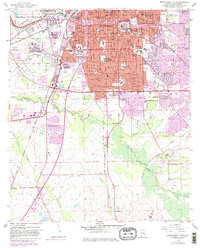
1958 Map of Montgomery South
USGS Topo · Published 1982About this map
Montgomery expands southward during the mid-20th century, anchored by major institutional and military hubs like Maxwell Air Force Base and its Maxwell Storage Annex. The city's academic and social fabric is clearly visible through the presence of Huntingdon College, Alabama State College, and several historical schools such as Lanier High Sch and Carver High Sch. The urban grid transitions into the surrounding rural landscape where small communities like Hope Hull and Snowdoun sit along the Louisville and Nashville Railroad and Seaboard Coast Line. South of the Montgomery Corporate Boundary, the terrain is defined by the winding course of Catoma Creek and Baldwin Slough, revealing a history of gravel extraction at numerous Gravel Pits. Significant local landmarks, including the St Jude Institution and several cemeteries like Greenwood Cemetery, highlight the cultural and genealogical importance of this Alabama state capital region.
Find a feature on this map
78 named features on this map. Tap any name to fly to it.
Don’t see what you’re looking for? This feature index may not catch every label — zoom into the map to look around manually.
Map Details
Editions of this 1958 Montgomery South Map
5 editions found
Other maps of this area

1927 · Montgomery
USGS Topo · 1:48,000

1930 · Montgomery
USGS Topo · 1:62,500

1953 · Montgomery
USGS Topo · 1:250,000

1956 · Montgomery
USGS Topo · 1:250,000

1957 · Montgomery
USGS Topo · 1:250,000

1957 · Letohatchee
USGS Topo · 1:62,500

1958 · Montgomery
USGS Topo · 1:62,500

1958 · Montgomery North
USGS Topo · 1:24,000

1958 · Montgomery South
USGS Topo · 1:24,000

1958 · Mount Meigs
USGS Topo · 1:62,500
Featured Places
- Montgomery, AL
- Perry Hills, Montgomery
- Cleveland Meadows, Montgomery
- Windwood, Montgomery
- Mayfair, Montgomery