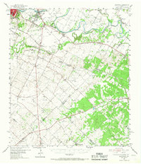
1955 Map of Montopolis
USGS Topo · Published 1967About this map
The Colorado River meanders across the northern reaches of this mid-century landscape, carving a fertile path through central Texas. Southeast of Austin, the settlement of Montopolis and the rural community of Del Valle anchor a region defined by scattered agricultural operations and burgeoning industry. The map reveals a transition from the urban fringes of the state capital to the rolling ranchlands of the Travis Co and Caldwell Co border, where early education is represented by numerous rural schools like Popham Sch and the now-silent Dry Creek Sch (Aband).
Find a feature on this map
66 named features on this map. Tap any name to fly to it.
Don’t see what you’re looking for? This feature index may not catch every label — zoom into the map to look around manually.
Map Details
Editions of this 1955 Montopolis Map
2 editions found

Other maps of this area

1885 · Bastrop
USGS Topo · 1:125,000

1893 · Bastrop
USGS Topo · 1:125,000

1896 · Austin
USGS Topo · 1:125,000

1897 · Austin
USGS Topo · 1:125,000

1901 · Flatonia
USGS Topo · 1:125,000

1904 · Bastrop
USGS Topo · 1:125,000

1910 · Austin
USGS Topo · 1:125,000

1911 · San Marcos
USGS Topo · 1:125,000

1919 · San Marcos
USGS Topo · 1:125,000

1930 · Lockhart
USGS Topo · 1:62,500