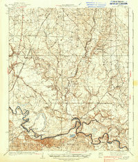
1938 Map of Moro Bay
USGS Topo · Published 1938About this map
The Ouachita River snakes along the boundary of Calhoun, Union, and Bradley counties, defining the river-driven economy of this 1930s landscape. This survey, conducted by the War Department and Geological Survey, highlights the critical river infrastructure of the era, including Lock 8 and several historic riverfront points such as Wilmington Landing, Stow Landing, and Caneville Landing. The terrain is characterized by complex wetland systems like Bilbo Lake and Short Brake, along with named ridges such as Harvin Ridge and Gilbert Ridge. Inland, the Chicago Rock Island and Pacific railroad cuts through the western sections, connecting small rural centers. This map is a rich resource for family historians, documenting numerous local institutions including Faustina Ch, Union Grove Ch, and a high density of rural schools like Jersey Sch and Ebenezer Sch.
Find a feature on this map
83 named features on this map. Tap any name to fly to it.
Don’t see what you’re looking for? This feature index may not catch every label — zoom into the map to look around manually.
Map Details
Editions of this 1938 Moro Bay Map
2 editions found

Other maps of this area

1903 · Camden
USGS Topo · 1:125,000

1927 · El Dorado
USGS Topo · 1:62,500

1930 · El Dorado
USGS Topo · 1:62,500

1933 · Strong
USGS Topo · 1:62,500

1934 · Ingalls
USGS Topo · 1:48,000

1934 · Felsenthal
USGS Topo · 1:62,500

1934 · Moro Bay
USGS Topo · 1:62,500

1937 · Strong
USGS Topo · 1:62,500

1937 · Felsenthal
USGS Topo · 1:62,500

1937 · Ingalls
USGS Topo · 1:62,500