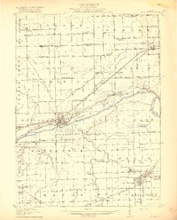
1918 Map of Morris
USGS Topo · Published 1918About this map
Morris sits at the heart of a bustling industrial and agricultural landscape where the Michigan and Illinois Canal parallels the Illinois River. In this 1915 survey, the river valley is a complex network of waterways and sloughs, including Peacock Slough and Nigger Slough, which divide the terrain before the Kankakee River joins from the southeast. To the south, the coal mining influence is evident in the dense settlement of Coal City, Carbon Hill, and Eileen, served by a concentrated web of rail lines like the Chicago and Alton RR. Rural life is marked by an exceptional density of named country schools, from the Jugtown School near Goose Lake to the Red Brick School on the river bluffs. The presence of the County Farm and multiple river crossings like the Pine Bluff Bridge reflect a well-established early 20th-century county infrastructure.
Find a feature on this map
102 named features on this map. Tap any name to fly to it.
Don’t see what you’re looking for? This feature index may not catch every label — zoom into the map to look around manually.
Map Details
Editions of this 1918 Morris Map
3 editions found
Other maps of this area

1892 · Morris
USGS Topo · 1:62,500

1892 · Marseilles
USGS Topo · 1:62,500

1892 · Joliet
USGS Topo · 1:62,500

1892 · Wilmington
USGS Topo · 1:62,500

1916 · Marseilles
USGS Topo · 1:62,500

1918 · Wilmington
USGS Topo · 1:62,500

1918 · Morris
USGS Topo · 1:62,500

1923 · Joliet
USGS Topo · 1:62,500

1923 · Herscher
USGS Topo · 1:62,500

1925 · Yorkville
USGS Topo · 1:62,500