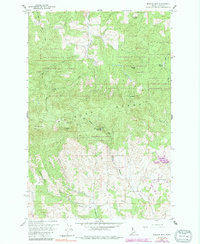
1960 Map of Moscow Mountain
USGS Topo · Published 1991About this map
The University of Idaho Experimental Forest dominates this section of the Palouse Range, serving as a massive living laboratory for forestry and resource management during the mid-twentieth century. The terrain is defined by high points like Moscow Mtn and Basalt Hill, with the East Moscow Lookout positioned to monitor the surrounding timberlands. Water management for nearby communities is evident in features such as the Village of Troy Reservoir and Spring Hill Reservoir. Local history is anchored by the Beulah Cem in the southern portion of the sheet near Randall Flat. Numerous drainages, including Hatter Creek and the East Fork Rock Creek, carve through the ridges, while various springs and 4WD tracks suggest the active recreational and utilitarian use of these highlands.
Find a feature on this map
25 named features on this map. Tap any name to fly to it.
Don’t see what you’re looking for? This feature index may not catch every label — zoom into the map to look around manually.
Map Details
Editions of this 1960 Moscow Mountain Map
5 editions found
Other maps of this area

1955 · Pullman
USGS Topo · 1:250,000

1958 · Pullman
USGS Topo · 1:250,000

1960 · Troy
USGS Topo · 1:24,000

1960 · Robinson Lake
USGS Topo · 1:24,000

1960 · Moscow Mtn
USGS Topo · 1:24,000

1960 · Moscow East
USGS Topo · 1:24,000

1960 · Potlatch
USGS Topo · 1:62,500

1961 · Deary
USGS Topo · 1:62,500

1961 · Kendrick
USGS Topo · 1:62,500

1961 · Moscow
USGS Topo · 1:62,500