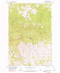
1960 Map of Moscow Mtn
USGS Topo · Published 1977About this map
The Palouse Range dominates this 1960s study area, where high-elevation landmarks like Moscow Mtn and the Moscow Mtn Lookout overlook a complex network of timbered ridges and creek drainages. The landscape transitions from the sharp elevations of Turnbow Point and Basalt Hill down to the agricultural and utility infrastructure in the valleys, such as the Village of Troy Reservoir on Big Meadow Creek.
Find a feature on this map
24 named features on this map. Tap any name to fly to it.
Don’t see what you’re looking for? This feature index may not catch every label — zoom into the map to look around manually.
Map Details
Editions of this 1960 Moscow Mtn Map
5 editions found
Other maps of this area

1955 · Pullman
USGS Topo · 1:250,000

1958 · Pullman
USGS Topo · 1:250,000

1960 · Troy
USGS Topo · 1:24,000

1960 · Robinson Lake
USGS Topo · 1:24,000

1960 · Moscow Mtn
USGS Topo · 1:24,000

1960 · Moscow East
USGS Topo · 1:24,000

1960 · Potlatch
USGS Topo · 1:62,500

1961 · Deary
USGS Topo · 1:62,500

1961 · Kendrick
USGS Topo · 1:62,500

1961 · Moscow
USGS Topo · 1:62,500