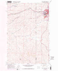
1964 Map of Moscow West
USGS Topo · Published 1978About this map
The western edge of Moscow and the sprawling University of Idaho campus dominate the eastern side of this map, marking a period of expansion where town and gown meet. The landscape is defined by the Whitman County and Latah County line, which also serves as the state border between Washington and Idaho. Infrastructure of the mid-20th century is prominent, including the Pullman-Moscow Regional Airport and a Drive-in Theater situated along the highway. Rail transportation remains a vital backbone for the region, with the Union Pacific and Northern Pacific lines following the path of Paradise Creek. To the south and west, the terrain transitions into the agricultural drainage of the South Fork Palouse River and Stratton Hollow, rising toward the landmark summit of Bald Butte. Small settlements like Sunshine and local landmarks such as a Cemetery and multiple Trailer Parks offer specific points of interest for local history and genealogical research.
Find a feature on this map
24 named features on this map. Tap any name to fly to it.
Don’t see what you’re looking for? This feature index may not catch every label — zoom into the map to look around manually.
Map Details
Editions of this 1964 Moscow West Map
3 editions found
Other maps of this area

1910 · Pullman
USGS Topo · 1:125,000

1955 · Pullman
USGS Topo · 1:250,000

1958 · Pullman
USGS Topo · 1:250,000

1960 · Robinson Lake
USGS Topo · 1:24,000

1960 · Moscow East
USGS Topo · 1:24,000

1960 · Potlatch
USGS Topo · 1:62,500

1961 · Moscow
USGS Topo · 1:62,500

1964 · Viola
USGS Topo · 1:24,000

1964 · Moscow West
USGS Topo · 1:24,000

1964 · Colton
USGS Topo · 1:24,000