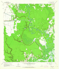
1961 Map of Moss Bluff
USGS Topo · Published 1964About this map
Industrial infrastructure and the winding Trinity River dominate this coastal Texas landscape, where the South Liberty Oil Field and Raymond Oil Field reveal the region's mid-century petroleum economy. The river's serpentine path is marked by dramatic oxbows and named reaches like Negro Bend and Demijohn Bend, creating a complex network of backwaters such as Demijohn Lake and Wooten Lake. Local transport and water management are evident in the straight lines of the Dayton Canal and the presence of the Moore Bluff Pumping Sta. Small settlements and family landmarks provide valuable points of reference for genealogists, particularly around Winfree, which includes the Winfree Ch and Winfree Cem. Further south, the map traces the Liberty Co Chambers Co line as it crosses The Cutoff and the marshy reaches of Picketts Bayou.
Find a feature on this map
44 named features on this map. Tap any name to fly to it.
Don’t see what you’re looking for? This feature index may not catch every label — zoom into the map to look around manually.
Map Details
Editions of this 1961 Moss Bluff Map
Other maps of this area

1916 · Cedar Bayou
USGS Topo · 1:24,000

1919 · Cedar Bayou
USGS Topo · 1:31,680

1942 · Anahuac
USGS Topo · 1:24,000

1943 · Liberty
USGS Topo · 1:125,000

1943 · Cedar Bayou
USGS Topo · 1:24,000

1950 · Houston
USGS Topo · 1:250,000

1954 · Beaumont
USGS Topo · 1:250,000

1955 · Daisetta
USGS Topo · 1:62,500

1955 · Liberty
USGS Topo · 1:62,500

1956 · Houston
USGS Topo · 1:250,000