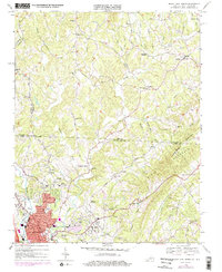
1968 Map of Mount Airy North
USGS Topo · Published 1978About this map
The Ararat River valley and its surrounding ridges anchor this 1960s study of the Piedmont borderlands, where the Blue Ridge begins to rise from the North Carolina and Virginia state line. The city of Mount Airy serves as the primary hub, showing early suburban expansion alongside established infrastructure like the Southern railroad and the Radio Tower (WPAQ). The settlement pattern reveals a landscape defined by small rural communities and mountain gaps, with clusters of activity around Ararat, The Hollow, and Toast.
Find a feature on this map
63 named features on this map. Tap any name to fly to it.
Don’t see what you’re looking for? This feature index may not catch every label — zoom into the map to look around manually.
Map Details
Editions of this 1968 Mount Airy North Map
3 editions found
Other maps of this area

1889 · Hillsville
USGS Topo · 1:125,000

1891 · Yadkinville
USGS Topo · 1:125,000

1892 · Hillsville
USGS Topo · 1:125,000

1893 · Yadkinville
USGS Topo · 1:125,000

1896 · Hillsville
USGS Topo · 1:125,000

1928 · Stuart
USGS Topo · 1:48,000

1931 · Stuart
USGS Topo · 1:62,500

1953 · Winston-Salem
USGS Topo · 1:250,000

1955 · Winston-Salem
USGS Topo · 1:250,000

1957 · Mount Airy
USGS Topo · 1:62,500