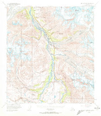
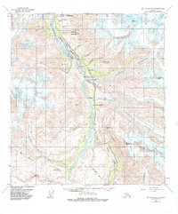
1954 Map of Mount Hayes B-4
USGS Topo · Published 1972About this map
Black Rapids Glacier and the massive Canwell Glacier dominate this rugged interior landscape where the Delta River carves a path through the Alaska Range. During the mid-twentieth century, the Richardson Highway served as the primary artery for northern transport, passing through the Black Rapids Training Site and past remote waypoints like Trims Camp. The map documents a transition in local commerce and travel, noting the Millers Roadhouse (Abandoned) and a small Miller Mine nearby. The glacial activity is highly detailed, showing the terminus of the Castner Glacier and the drainage patterns of Phelan Creek and Rainbow Creek against the steep elevations of Rainbow Mountain and the Rainbow Ridge. These topographical details provide a precise record of ice positions and high-altitude terrain near Rainy Mountain and Mt Silvertip before late-century shifts.
Find a feature on this map
33 named features on this map. Tap any name to fly to it.
Don’t see what you’re looking for? This feature index may not catch every label — zoom into the map to look around manually.
Map Details
Editions of this 1954 Mount Hayes B-4 Map
6 editions found

Other maps of this area

1949 · Mount Hayes A-4
USGS Topo · 1:63,360

1949 · Mount Hayes A-5
USGS Topo · 1:63,360

1950 · Mount Hayes
USGS Topo · 1:250,000

1950 · Mount Hayes C-4
USGS Topo · 1:63,360

1950 · Mount Hayes A-3
USGS Topo · 1:63,360

1951 · Mount Hayes
USGS Topo · 1:250,000

1951 · Mount Hayes C-5
USGS Topo · 1:63,360

1951 · Mt. Hayes B-5
USGS Topo · 1:63,360

1952 · Mount Hayes A-3
USGS Topo · 1:63,360

1952 · Mount Hayes A-4
USGS Topo · 1:63,360