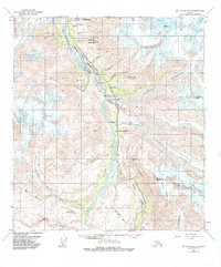
1954 Map of Mt. Hayes B-4
USGS Topo · Published 1985About this map
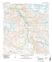
The Delta River corridor serves as a vital artery through this Alaskan interior landscape, where mid-century transportation and energy infrastructure converge alongside massive ice fields. The Richardson Highway parallels the river, providing access to remote outposts such as Trims Camp and Millers Roadhouse. This segment of the valley also serves as a utility corridor, housing the Trans-Alaska Pipeline (Underground) and Pump Sta 10. The eastern half of the map is dominated by the sprawling reaches of the Castner Glacier and Canwell Glacier, while high peaks like Rainbow Mountain and Mt Silvertip define the vertical scale of the terrain. Local industrial efforts are marked by the Miller Mine and a Gravel Pit, positioned where the highway skirts the river's edge, highlighting the continuous human effort to maintain a passage through this glacial environment.
Find a feature on this map
38 named features on this map. Tap any name to fly to it.
Don’t see what you’re looking for? This feature index may not catch every label — zoom into the map to look around manually.
Map Details
Editions of this 1954 Mt. Hayes B-4 Map
6 editions found

Other maps of this area

1949 · Mount Hayes A-4
USGS Topo · 1:63,360

1949 · Mount Hayes A-5
USGS Topo · 1:63,360

1950 · Mount Hayes
USGS Topo · 1:250,000

1950 · Mount Hayes C-4
USGS Topo · 1:63,360

1950 · Mount Hayes A-3
USGS Topo · 1:63,360

1951 · Mount Hayes
USGS Topo · 1:250,000

1951 · Mount Hayes C-5
USGS Topo · 1:63,360

1951 · Mt. Hayes B-5
USGS Topo · 1:63,360

1952 · Mount Hayes A-3
USGS Topo · 1:63,360

1952 · Mount Hayes A-4
USGS Topo · 1:63,360