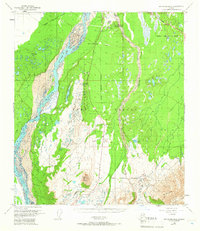
1950 Map of Mount Hayes D-4
USGS Topo · Published 1966About this map
The Fort Greely Military Reservation Boundary dominates the eastern and central portion of this landscape, reflecting a period of intense Cold War strategic development in interior Alaska. Established in the mid-20th century, the post is anchored by the Big Delta Arctic Training Center and supported by infrastructure including the CAA Station and Big Delta Airport. The Richardson Highway serves as the primary ground artery, cutting through the terrain alongside the braided channels of the Delta River. In the southern reaches of the map, Donnelly Dome rises as a prominent landmark above a terrain marked by numerous kettle lakes, such as Bolio Lake and Big Lake, and the drainage of Jarvis Creek. This survey captures the integration of military utility and natural geography before the expansion of later decades.
Find a feature on this map
17 named features on this map. Tap any name to fly to it.
Don’t see what you’re looking for? This feature index may not catch every label — zoom into the map to look around manually.
Map Details
Editions of this 1950 Mount Hayes D-4 Map
5 editions found
Other maps of this area

1950 · Mount Hayes
USGS Topo · 1:250,000

1950 · Big Delta
USGS Topo · 1:250,000

1950 · Big Delta A-5
USGS Topo · 1:63,360

1950 · Mount Hayes D-4
USGS Topo · 1:63,360

1950 · Mount Hayes C-4
USGS Topo · 1:63,360

1950 · Big Delta A-4
USGS Topo · 1:63,360

1950 · Mount Hayes D-5
USGS Topo · 1:63,360

1951 · Big Delta
USGS Topo · 1:250,000

1951 · Mount Hayes
USGS Topo · 1:250,000

1951 · Mount Hayes C-5
USGS Topo · 1:63,360