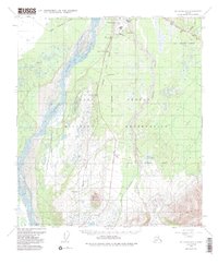
1950 Map of Mount Hayes D-4
USGS Topo · Published 1988About this map
Fort Greely Military Reservation dominates this landscape south of the Tanana River, where military infrastructure meets the Interior Alaska wilderness. The Richardson Highway and Trans-Alaska Pipeline serve as a critical north-south corridor, running parallel between the massive Delta River and the winding course of Jarvis Creek. The settlement of Donnelly and the prominent Donnelly Dome provide landmark orientation for those traveling through this remote terrain.
Find a feature on this map
19 named features on this map. Tap any name to fly to it.
Don’t see what you’re looking for? This feature index may not catch every label — zoom into the map to look around manually.
Map Details
Editions of this 1950 Mount Hayes D-4 Map
5 editions found
Other maps of this area

1950 · Mount Hayes
USGS Topo · 1:250,000

1950 · Big Delta
USGS Topo · 1:250,000

1950 · Big Delta A-5
USGS Topo · 1:63,360

1950 · Mount Hayes D-4
USGS Topo · 1:63,360

1950 · Mount Hayes C-4
USGS Topo · 1:63,360

1950 · Big Delta A-4
USGS Topo · 1:63,360

1950 · Mount Hayes D-5
USGS Topo · 1:63,360

1951 · Big Delta
USGS Topo · 1:250,000

1951 · Mount Hayes
USGS Topo · 1:250,000

1951 · Mount Hayes C-5
USGS Topo · 1:63,360