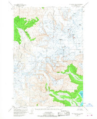
1951 Map of Mount Katmai B-2
USGS Topo · Published 1968About this map
Katmai National Monument dominates this mid-century topographic record, capturing the high-altitude ice and volcanic features of the Alaska Peninsula. Based on 1951 aerial photography, the landscape is defined by massive glacial systems such as Hook Glacier and the strikingly named Serpent Tongue Glacier. These frozen rivers descend from a skyline marked by peaks like Mt Denison, Mt Stellar, and the Kukak Volcano. The presence of numerous crevasses noted across the ice fields highlights the active, shifting nature of the terrain during this era of survey. In the southeast, the elevation drops sharply toward the marine environment of Kukak Bay, where the glacial influence meets the Pacific coast. This map serves as a primary source for the geomorphology of the Katmai region before later twentieth-century environmental shifts.
Find a feature on this map
9 named features on this map. Tap any name to fly to it.
Don’t see what you’re looking for? This feature index may not catch every label — zoom into the map to look around manually.
Map Details
Editions of this 1951 Mount Katmai B-2 Map
3 editions found

Other maps of this area

1948 · Mt Katmai
USGS Topo · 1:250,000

1951 · Mt Katmai
USGS Topo · 1:250,000

1951 · Mount Katmai A-3
USGS Topo · 1:63,360

1951 · Mount Katmai C-3
USGS Topo · 1:63,360

1951 · Mount Katmai A-2
USGS Topo · 1:63,360
1951 · Mount Katmai A-1
USGS Topo · 1:63,360

1951 · Mount Katmai C-2
USGS Topo · 1:63,360

1951 · Mount Katmai C-1
USGS Topo · 1:63,360

1951 · Mount Katmai B-3
USGS Topo · 1:63,360

1951 · Mount Katmai B-1
USGS Topo · 1:63,360