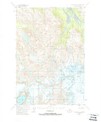
1951 Map of Mount Katmai B-3
USGS Topo · Published 1971About this map
Katmai National Monument dominates this 1951 topographic study, capturing a high-altitude landscape defined by massive glacial systems and volcanic peaks. The map reveals the dramatic topography of Mt Katmai and the neighboring Snowy Mountain, where the Serpent Tongue Glacier flows through deep valleys. Extensive fields of Crevasses are marked across the ice sheets, indicating the active nature of the glaciers at mid-century.
Find a feature on this map
10 named features on this map. Tap any name to fly to it.
Don’t see what you’re looking for? This feature index may not catch every label — zoom into the map to look around manually.
Map Details
Editions of this 1951 Mount Katmai B-3 Map
3 editions found
Other maps of this area

1948 · Mt Katmai
USGS Topo · 1:250,000

1951 · Mt Katmai
USGS Topo · 1:250,000

1951 · Mount Katmai A-3
USGS Topo · 1:63,360

1951 · Mount Katmai C-3
USGS Topo · 1:63,360

1951 · Mount Katmai B-4
USGS Topo · 1:63,360

1951 · Mount Katmai C-4
USGS Topo · 1:63,360

1951 · Mount Katmai A-2
USGS Topo · 1:63,360

1951 · Mount Katmai C-2
USGS Topo · 1:63,360

1951 · Mount Katmai A-4
USGS Topo · 1:63,360

1951 · Mount Katmai B-3
USGS Topo · 1:63,360