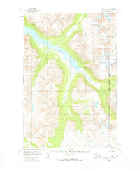
1951 Map of Mount Katmai D-3
USGS Topo · Published 1973About this map
Kulik Lake dominates this 1951 topographic survey, stretching through the center of a landscape defined by sharp drainage patterns and significant elevation changes. The northeastern portion of the map identifies the McNeil River State Game Sanctuary, indicating the early 1950s boundaries of this protected habitat area. The McNeil River flows toward the east, while Pirate Lake sits tucked into the high terrain near the northern quadrangle boundary.
Find a feature on this map
5 named features on this map. Tap any name to fly to it.
Don’t see what you’re looking for? This feature index may not catch every label — zoom into the map to look around manually.
Map Details
Editions of this 1951 Mount Katmai D-3 Map
2 editions found
Other maps of this area

1948 · Mt Katmai
USGS Topo · 1:250,000

1951 · Mt Katmai
USGS Topo · 1:250,000

1951 · Iliamna A-5
USGS Topo · 1:63,360

1951 · Mount Katmai C-3
USGS Topo · 1:63,360

1951 · Mount Katmai C-4
USGS Topo · 1:63,360

1951 · Mount Katmai C-2
USGS Topo · 1:63,360

1951 · Mount Katmai D-4
USGS Topo · 1:63,360

1951 · Mount Katmai D-2
USGS Topo · 1:63,360

1951 · Mount Katmai D-3
USGS Topo · 1:63,360

1951 · Iliamna A-6
USGS Topo · 1:63,360