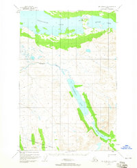
1951 Map of Mount Katmai D-4
USGS Topo · Published 1965About this map
Site of Ancient Village sits along the northern shores of Kulik Lake, marking a historical human footprint in this wilderness landscape surveyed in the early 1950s. The map covers the northern reaches of the Katmai National Monument, showing the transition from large glacial waters to the surrounding high country. Transportation in this roadless area is defined by the Seaplane Base on the western end of the lake and a remote Landing Strip to the south. Central to the topography is the long, narrow corridor of Hammersly Lake, which feeds into Murray Lake at the southeastern corner. The intricate drainage of American Creek connects the higher elevations to Nonvianuk Lake, illustrating the complex hydrology of the Alaska Peninsula before modern infrastructure altered these corridors.
Find a feature on this map
12 named features on this map. Tap any name to fly to it.
Don’t see what you’re looking for? This feature index may not catch every label — zoom into the map to look around manually.
Map Details
Editions of this 1951 Mount Katmai D-4 Map
3 editions found
Other maps of this area

1948 · Mt Katmai
USGS Topo · 1:250,000

1951 · Mt Katmai
USGS Topo · 1:250,000

1951 · Mount Katmai C-3
USGS Topo · 1:63,360

1951 · Mount Katmai D-5
USGS Topo · 1:63,360

1951 · Mount Katmai C-5
USGS Topo · 1:63,360

1951 · Iliamna A-7
USGS Topo · 1:63,360

1951 · Mount Katmai C-4
USGS Topo · 1:63,360

1951 · Mount Katmai D-4
USGS Topo · 1:63,360

1951 · Mount Katmai D-3
USGS Topo · 1:63,360

1951 · Iliamna A-6
USGS Topo · 1:63,360