1976 Map of Mount Le Conte
USGS Topo · Published 1978About this map
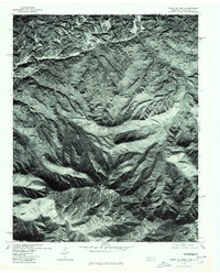
Gatlinburg and the surrounding high-elevation peaks are captured in this orthophotograph, created from aerial imagery taken in November 1976. Unlike traditional line-drawn maps, this photo-rectified survey shows the actual forest canopy and land-use patterns across the State Line Divide during the mid-1970s. The image provides a detailed view of the terrain around Mount Le Conte and Anakeeesta Knob, where the natural drainage and dense vegetation define the landscape. Small settlements like Cartertown and Glade appear at the northern edges, illustrating how human development in this corner of Tennessee met the rising slopes of the great southern highlands. This specific orthophotoquad is a collaboration between the Geological Survey and the North Carolina Department of Natural Resources and Community Development, documenting the region's topography through automatic correlation of imagery.
Find a feature on this map
6 named features on this map. Tap any name to fly to it.
Don’t see what you’re looking for? This feature index may not catch every label — zoom into the map to look around manually.
Map Details
Editions of this 1976 Mount Le Conte Map
This is the sole edition of this map. No revisions or reprints were ever made.
Other maps of this area

1886 · Knoxville
USGS Topo · 1:125,000

1892 · Knoxville
USGS Topo · 1:125,000

1893 · Mt Guyot
USGS Topo · 1:125,000

1894 · Knoxville
USGS Topo · 1:125,000

1895 · Knoxville
USGS Topo · 1:125,000

1901 · Knoxville
USGS Topo · 1:125,000

1912 · Mt Guyot
USGS Topo · 1:125,000

1935 · English Mountain
USGS Topo · 1:48,000

1935 · Jones Cove
USGS Topo · 1:24,000

1935 · Richardson Cove
USGS Topo · 1:24,000