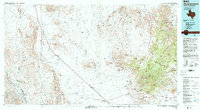
1985 Map of Mount Livermore
USGS Topo · Published 1993About this map
Lobo Valley serves as a corridor for the Southern Pacific railroad and U.S. 90, cutting between the high peaks of the Van Horn Mountains and the Sierra Vieja. This mid-1980s landscape is dominated by the massive profile of Mount Livermore and Baldy Peak to the east, where the terrain shifts from the arid flats of Ninety-six Creek into the high Davis Mountains. Small rail settlements like Valentine, Quebec, and Chispa trace the transportation network that sustained ranching and mining operations in this border region. To the north, the Plata Verde Mines sit tucked into the foothills, while the complex drainage patterns of Tally Slough and Ninemile Draw illustrate the catchment areas of the surrounding ranges. The map also delineates the international border with the United States of America and Mexico along the Rio Grande.
Find a feature on this map
115 named features on this map. Tap any name to fly to it.
Don’t see what you’re looking for? This feature index may not catch every label — zoom into the map to look around manually.
Map Details
Editions of this 1985 Mount Livermore Map
3 editions found
Other maps of this area

1892 · Chispa
USGS Topo · 1:125,000

1894 · Valentine
USGS Topo · 1:125,000

1894 · Fort Davis
USGS Topo · 1:125,000

1895 · Chispa
USGS Topo · 1:125,000

1895 · Marfa
USGS Topo · 1:125,000

1895 · Sierra Blanca
USGS Topo · 1:125,000

1895 · Alpine
USGS Topo · 1:125,000

1896 · San Carlos
USGS Topo · 1:125,000

1897 · Valentine
USGS Topo · 1:125,000

1897 · Fort Davis
USGS Topo · 1:125,000