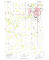
1973 Map of Mount Pleasant
USGS Topo · Published 1976About this map
Mount Pleasant serves as a significant regional hub during the early 1970s, defined by the expanding campus of Central Michigan University and a dense network of civic and educational institutions. The city center is anchored by the Courthouse and the Post Office, while the surrounding neighborhoods are served by numerous schools such as Kinney Sch, Ganiard Sch, and Sacred Heart Academy. The Ann Arbor Railroad and Chesapeake and Ohio Railroad intersect within the city limits, illustrating the importance of rail transport for this Isabella County community.
Find a feature on this map
58 named features on this map. Tap any name to fly to it.
Don’t see what you’re looking for? This feature index may not catch every label — zoom into the map to look around manually.
Map Details
Editions of this 1973 Mount Pleasant Map
This is the sole edition of this map. No revisions or reprints were ever made.
Other maps of this area

1916 · Mount Pleasant
USGS Topo · 1:62,500

1919 · Mount Pleasant
USGS Topo · 1:62,500

1930 · Shepherd
USGS Topo · 1:48,000

1935 · Alma
USGS Topo · 1:62,500

1936 · Shepherd
USGS Topo · 1:62,500

1938 · Alma
USGS Topo · 1:62,500

1943 · Mount Pleasant
USGS Topo · 1:62,500

1954 · Midland
USGS Topo · 1:250,000

1958 · Midland
USGS Topo · 1:250,000

1959 · Midland
USGS Topo · 1:250,000