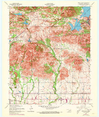
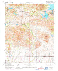
1956 Map of Mount Scott
USGS Topo · Published 1973About this map
Wichita Mountains Wildlife Refuge and the Fort Sill Military Reservation dominate this mid-century landscape in Comanche County. The map provides a look at the intersection of protected wilderness and military training grounds, featuring rugged peaks like Mount Scott and Mount Roosevelt. Water resources are central to the area's development, seen in the expansive Lake Lawtonka and Elmer Thomas Lake, which support the nearby resort community of Medicine Park. Cultural landmarks of the era are clearly marked, including the Holy City Chapel and the site of the Easter Pageant. To the south, the town of Cache serves as a gateway to the mountains, situated along the St Louis San Francisco railroad. The map also captures several landing strips, such as Ketch Field Landing Strip, and numerous family-named peaks and ridges that define the local geography before 1970s revisions.
Find a feature on this map
61 named features on this map. Tap any name to fly to it.
Don’t see what you’re looking for? This feature index may not catch every label — zoom into the map to look around manually.
Map Details
Editions of this 1956 Mount Scott Map
5 editions found
Other maps of this area

1937 · Cache
USGS Topo · 1:48,000

1937 · Quanah Mountain
USGS Topo · 1:24,000

1942 · Cache
USGS Topo · 1:62,500

1946 · Lawton
USGS Topo · 1:62,500

1949 · Mount Scott
USGS Topo · 1:24,000

1949 · Quanah Mountain
USGS Topo · 1:24,000

1949 · Fort Sill
USGS Topo · 1:24,000

1950 · Saddle Mountain
USGS Topo · 1:62,500

1955 · Lawton
USGS Topo · 1:250,000

1956 · Post Oak Creek
USGS Topo · 1:24,000