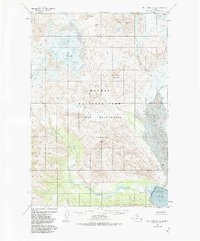
1951 Map of Mt. Katmai A-4
USGS Topo · Published 1985About this map
Trident Volcano and the massive Mt Mageik dominate this 1951 topographic study of the northern Alaska Peninsula. The landscape is defined by extreme volcanic activity and drainage patterns, including the notable Mageik Landslide located between the peaks and the valley floor. To the south, the Katmai River flows into Katmai Bay, where a large Tidal Flat marks the coastal transition. This area, largely untouched by permanent settlement, is preserved within the Katmai National Park and Katmai Wilderness.
Find a feature on this map
16 named features on this map. Tap any name to fly to it.
Don’t see what you’re looking for? This feature index may not catch every label — zoom into the map to look around manually.
Map Details
Editions of this 1951 Mt. Katmai A-4 Map
4 editions found
Historical Maps of Kodiak Island Through Time
335 maps found

1947 Kodiak D-3
Kodiak Island Borough, AK

1949 Kodiak A-3
Kodiak Island Borough, AK

1949 Kodiak B-1 and B-2
Kodiak Island Borough, AK

1949 Kodiak B-3
Kodiak Island Borough, AK

1949 Kodiak C-1
Kodiak Island Borough, AK

1949 Kodiak C-2
Kodiak Island Borough, AK

1949 Kodiak D-1
Kodiak Island Borough, AK

1949 Kodiak D-2
Kodiak Island Borough, AK

1949 Kodiak D-3
Kodiak Island Borough, AK

1950 Kodiak A-3
Kodiak Island Borough, AK

1950 Kodiak B-3
Kodiak Island Borough, AK

1950 Kodiak D-3
Kodiak Island Borough, AK

1951 Afognak C-5
Kodiak Island Borough, AK

1951 Afognak C-6
Kodiak Island Borough, AK

1951 Afognak D-1
Kodiak Island Borough, AK

1951 Kaguyak
Kodiak Island Borough, AK

1951 Karluk C-4 and C-5
Kodiak Island Borough, AK

1951 Karluk C-6
Kodiak Island Borough, AK

1951 Karluk D-4
Kodiak Island Borough, AK

1951 Kodiak B-1 and B-2
Kodiak Island Borough, AK

1951 Kodiak C-1
Kodiak Island Borough, AK

1951 Kodiak D-1
Kodiak Island Borough, AK

1951 Kodiak D-2
Kodiak Island Borough, AK

1951 Kodiak D-6
Kodiak Island Borough, AK

1951 Mount Katmai A-1
Kodiak Island Borough, AK

1951 Mount Katmai A-3
Kodiak Island Borough, AK

1951 Mount Katmai B-1
Kodiak Island Borough, AK

1951 Mount Katmai C-1
Kodiak Island Borough, AK

1951 Mt. Katmai A-2
Kodiak Island Borough, AK

1951 Mt. Katmai A-4
Kodiak Island Borough, AK

1951 Mt. Katmai B-2
Kodiak Island Borough, AK

1951 Trinity Islands
Kodiak Island Borough, AK

1951 Ugashik B-1
Kodiak Island Borough, AK

1951 Ugashik B-2
Kodiak Island Borough, AK

1952 Afognak A-0 and B-0
Kodiak Island Borough, AK

1952 Afognak A-1
Kodiak Island Borough, AK

1952 Afognak A-2
Kodiak Island Borough, AK

1952 Afognak A-3
Kodiak Island Borough, AK

1952 Afognak A-4
Kodiak Island Borough, AK

1952 Afognak A-5
Kodiak Island Borough, AK

1952 Afognak B-1
Kodiak Island Borough, AK

1952 Afognak B-2
Kodiak Island Borough, AK

1952 Afognak B-4
Kodiak Island Borough, AK

1952 Afognak C-1 and C-2
Kodiak Island Borough, AK

1952 Afognak C-2 and C-3
Kodiak Island Borough, AK

1952 Afognak
Kodiak Island Borough, AK

1952 Kaguyak D-5
Kodiak Island Borough, AK

1952 Kaguyak D-6
Kodiak Island Borough, AK

1952 Kaguyak
Kodiak Island Borough, AK

1952 Karluk A-1
Kodiak Island Borough, AK

1952 Karluk A-2
Kodiak Island Borough, AK

1952 Karluk B-1
Kodiak Island Borough, AK

1952 Karluk B-2
Kodiak Island Borough, AK

1952 Karluk B-3
Kodiak Island Borough, AK

1952 Karluk C-1
Kodiak Island Borough, AK

1952 Karluk C-2
Kodiak Island Borough, AK

1952 Kodiak A-4
Kodiak Island Borough, AK

1952 Kodiak A-5
Kodiak Island Borough, AK

1952 Kodiak A-6
Kodiak Island Borough, AK

1952 Kodiak B-4
Kodiak Island Borough, AK

1952 Kodiak B-5
Kodiak Island Borough, AK

1952 Kodiak B-6
Kodiak Island Borough, AK

1952 Kodiak C-3
Kodiak Island Borough, AK

1952 Kodiak C-4
Kodiak Island Borough, AK

1952 Kodiak C-5
Kodiak Island Borough, AK

1952 Kodiak C-6
Kodiak Island Borough, AK

1952 Kodiak D-4
Kodiak Island Borough, AK

1952 Kodiak D-5
Kodiak Island Borough, AK

1952 Trinity Islands B-2 and C-2
Kodiak Island Borough, AK

1952 Trinity Islands B-3 and C-3
Kodiak Island Borough, AK

1952 Trinity Islands C-1
Kodiak Island Borough, AK

1952 Trinity Islands D-1
Kodiak Island Borough, AK

1952 Trinity Islands D-2
Kodiak Island Borough, AK

1953 Afognak A-0 and B-0
Kodiak Island Borough, AK

1953 Afognak A-1
Kodiak Island Borough, AK

1953 Afognak A-4
Kodiak Island Borough, AK

1953 Afognak A-5
Kodiak Island Borough, AK

1953 Trinity Islands B-3 and C-3
Kodiak Island Borough, AK

1954 Afognak A-2
Kodiak Island Borough, AK

1954 Afognak A-3
Kodiak Island Borough, AK

1954 Afognak B-1
Kodiak Island Borough, AK

1954 Afognak B-2
Kodiak Island Borough, AK

1954 Afognak B-3
Kodiak Island Borough, AK

1954 Afognak B-4
Kodiak Island Borough, AK

1954 Afognak C-1 and C-2
Kodiak Island Borough, AK

1954 Afognak C-2 and C-3
Kodiak Island Borough, AK

1954 Kaguyak C-6
Kodiak Island Borough, AK

1954 Kaguyak D-5
Kodiak Island Borough, AK

1954 Kaguyak D-6
Kodiak Island Borough, AK

1954 Karluk A-1
Kodiak Island Borough, AK

1954 Karluk A-2
Kodiak Island Borough, AK

1954 Karluk B-1
Kodiak Island Borough, AK

1954 Karluk B-2
Kodiak Island Borough, AK

1954 Karluk B-3
Kodiak Island Borough, AK

1954 Karluk C-1
Kodiak Island Borough, AK

1954 Karluk C-2
Kodiak Island Borough, AK

1954 Kodiak A-4
Kodiak Island Borough, AK

1954 Kodiak A-5
Kodiak Island Borough, AK

1954 Kodiak A-6
Kodiak Island Borough, AK

1954 Kodiak B-4
Kodiak Island Borough, AK

1954 Kodiak B-5
Kodiak Island Borough, AK

1954 Kodiak B-6
Kodiak Island Borough, AK

1954 Kodiak C-3
Kodiak Island Borough, AK

1954 Kodiak C-4
Kodiak Island Borough, AK

1954 Kodiak C-5
Kodiak Island Borough, AK

1954 Kodiak C-6
Kodiak Island Borough, AK

1954 Kodiak D-4
Kodiak Island Borough, AK

1954 Kodiak D-5
Kodiak Island Borough, AK

1954 Kodiak D-6
Kodiak Island Borough, AK

1954 Trinity Islands B-2 and C-2
Kodiak Island Borough, AK

1954 Trinity Islands C-1
Kodiak Island Borough, AK

1954 Trinity Islands D-1
Kodiak Island Borough, AK

1954 Trinity Islands D-2
Kodiak Island Borough, AK

1954 Trinity Islands
Kodiak Island Borough, AK

1963 Sutwik Island A-3
Kodiak Island Borough, AK

1965 Kodiak D-4
Kodiak Island Borough, AK

1971 Karluk C-4 and C-5
Kodiak Island Borough, AK

1987 Kodiak B-1 NW
Kodiak Island Borough, AK

1987 Kodiak B-2 NE
Kodiak Island Borough, AK

1987 Kodiak C-1 NE
Kodiak Island Borough, AK

1987 Kodiak C-1 NW
Kodiak Island Borough, AK

1987 Kodiak C-1 SE
Kodiak Island Borough, AK

1987 Kodiak C-1 SW
Kodiak Island Borough, AK

1987 Kodiak C-2 NE
Kodiak Island Borough, AK

1987 Kodiak C-2 NW
Kodiak Island Borough, AK

1987 Kodiak C-2 SE
Kodiak Island Borough, AK

1987 Kodiak D-1 SW
Kodiak Island Borough, AK

1987 Kodiak D-2 SE
Kodiak Island Borough, AK

1987 Kodiak D-2 SW
Kodiak Island Borough, AK

2019 Afognak C-5 NE
Kodiak Island Borough, AK

2019 Afognak C-5 NW
Kodiak Island Borough, AK

2019 Afognak C-5 SW
Kodiak Island Borough, AK

2019 Afognak C-6 NE
Kodiak Island Borough, AK

2019 Afognak C-6 NW
Kodiak Island Borough, AK

2019 Afognak C-6 SE
Kodiak Island Borough, AK

2019 Afognak C-6 SW
Kodiak Island Borough, AK

2019 Afognak D-4 SW
Kodiak Island Borough, AK

2019 Afognak D-5 SE
Kodiak Island Borough, AK

2019 Afognak D-5 SW
Kodiak Island Borough, AK

2019 Karluk C-4 NW
Kodiak Island Borough, AK

2019 Karluk C-5 NE
Kodiak Island Borough, AK

2019 Karluk C-5 NW
Kodiak Island Borough, AK

2019 Karluk C-6 NE
Kodiak Island Borough, AK

2019 Karluk C-6 SE
Kodiak Island Borough, AK

2019 Karluk C-6 SW
Kodiak Island Borough, AK

2019 Karluk D-4 NE
Kodiak Island Borough, AK

2019 Karluk D-4 NW
Kodiak Island Borough, AK

2019 Karluk D-4 SE
Kodiak Island Borough, AK

2019 Karluk D-4 SW
Kodiak Island Borough, AK

2019 Karluk D-5 SE
Kodiak Island Borough, AK

2021 Afognak A-0 NE
Kodiak Island Borough, AK

2021 Afognak A-0 NW
Kodiak Island Borough, AK

2021 Afognak A-1 NE
Kodiak Island Borough, AK

2021 Afognak A-1 NW
Kodiak Island Borough, AK

2021 Afognak A-1 SW
Kodiak Island Borough, AK

2021 Afognak A-2 NE
Kodiak Island Borough, AK

2021 Afognak A-2 NW
Kodiak Island Borough, AK

2021 Afognak A-2 SE
Kodiak Island Borough, AK

2021 Afognak A-2 SW
Kodiak Island Borough, AK

2021 Afognak A-3 NE
Kodiak Island Borough, AK

2021 Afognak A-3 NW
Kodiak Island Borough, AK

2021 Afognak A-3 SE
Kodiak Island Borough, AK

2021 Afognak A-3 SW
Kodiak Island Borough, AK

2021 Afognak A-4 NE
Kodiak Island Borough, AK

2021 Afognak A-4 NW
Kodiak Island Borough, AK

2021 Afognak A-4 SE
Kodiak Island Borough, AK

2021 Afognak A-4 SW
Kodiak Island Borough, AK

2021 Afognak A-5 SE
Kodiak Island Borough, AK

2021 Afognak B-0 SE
Kodiak Island Borough, AK

2021 Afognak B-0 SW
Kodiak Island Borough, AK

2021 Afognak B-1 NE
Kodiak Island Borough, AK

2021 Afognak B-1 NW
Kodiak Island Borough, AK

2021 Afognak B-1 SE
Kodiak Island Borough, AK

2021 Afognak B-1 SW
Kodiak Island Borough, AK

2021 Afognak B-2 NE
Kodiak Island Borough, AK

2021 Afognak B-2 NW
Kodiak Island Borough, AK

2021 Afognak B-2 SE
Kodiak Island Borough, AK

2021 Afognak B-2 SW
Kodiak Island Borough, AK

2021 Afognak B-3 NE
Kodiak Island Borough, AK

2021 Afognak B-3 NW
Kodiak Island Borough, AK

2021 Afognak B-3 SE
Kodiak Island Borough, AK

2021 Afognak B-3 SW
Kodiak Island Borough, AK

2021 Afognak B-4 SE
Kodiak Island Borough, AK

2021 Afognak C-1 NW
Kodiak Island Borough, AK

2021 Afognak C-1 SE
Kodiak Island Borough, AK

2021 Afognak C-1 SW
Kodiak Island Borough, AK

2021 Afognak C-2 NE
Kodiak Island Borough, AK

2021 Afognak C-2 NW
Kodiak Island Borough, AK

2021 Afognak C-2 SE
Kodiak Island Borough, AK

2021 Afognak C-2 SW
Kodiak Island Borough, AK

2021 Afognak C-3 SE
Kodiak Island Borough, AK

2021 Afognak D-1 NE
Kodiak Island Borough, AK

2021 Afognak D-1 NW
Kodiak Island Borough, AK

2021 Afognak D-1 OE E NW
Kodiak Island Borough, AK

2021 Afognak D-1 OE W NE
Kodiak Island Borough, AK

2021 Chirikof Island D-5 OE E NW
Kodiak Island Borough, AK

2021 Chirikof Island D-5 OE E SW
Kodiak Island Borough, AK

2021 Chirikof Island D-5 SE
Kodiak Island Borough, AK

2021 Kaguyak C-6 NE
Kodiak Island Borough, AK

2021 Kaguyak C-6 NW
Kodiak Island Borough, AK

2021 Kaguyak C-6 OE S NW
Kodiak Island Borough, AK

2021 Kaguyak C-6 SW
Kodiak Island Borough, AK

2021 Kaguyak D-5 NE
Kodiak Island Borough, AK

2021 Kaguyak D-5 NW
Kodiak Island Borough, AK

2021 Kaguyak D-5 SW
Kodiak Island Borough, AK

2021 Kaguyak D-6 NE
Kodiak Island Borough, AK

2021 Kaguyak D-6 NW
Kodiak Island Borough, AK

2021 Kaguyak D-6 SE
Kodiak Island Borough, AK

2021 Kaguyak D-6 SW
Kodiak Island Borough, AK

2021 Karluk A-1 NE
Kodiak Island Borough, AK

2021 Karluk A-1 NW
Kodiak Island Borough, AK

2021 Karluk A-1 SE
Kodiak Island Borough, AK

2021 Karluk A-1 SW
Kodiak Island Borough, AK

2021 Karluk A-2 NE
Kodiak Island Borough, AK

2021 Karluk A-2 NW
Kodiak Island Borough, AK

2021 Karluk A-2 SE
Kodiak Island Borough, AK

2021 Karluk A-2 SW
Kodiak Island Borough, AK

2021 Karluk B-1 NE
Kodiak Island Borough, AK

2021 Karluk B-1 NW
Kodiak Island Borough, AK

2021 Karluk B-1 SE
Kodiak Island Borough, AK

2021 Karluk B-1 SW
Kodiak Island Borough, AK

2021 Karluk B-2 NE
Kodiak Island Borough, AK

2021 Karluk B-2 NW
Kodiak Island Borough, AK

2021 Karluk B-2 SE
Kodiak Island Borough, AK

2021 Karluk B-2 SW
Kodiak Island Borough, AK

2021 Karluk B-3 NE
Kodiak Island Borough, AK

2021 Karluk B-3 SE
Kodiak Island Borough, AK

2021 Karluk C-1 NE
Kodiak Island Borough, AK

2021 Karluk C-1 NW
Kodiak Island Borough, AK

2021 Karluk C-1 SE
Kodiak Island Borough, AK

2021 Karluk C-1 SW
Kodiak Island Borough, AK

2021 Karluk C-2 NE
Kodiak Island Borough, AK

2021 Karluk C-2 SE
Kodiak Island Borough, AK

2021 Karluk C-2 SW
Kodiak Island Borough, AK

2021 Kodiak A-3 NW
Kodiak Island Borough, AK

2021 Kodiak A-3 SW
Kodiak Island Borough, AK

2021 Kodiak A-4 NE
Kodiak Island Borough, AK

2021 Kodiak A-4 NW
Kodiak Island Borough, AK

2021 Kodiak A-4 OE S NE
Kodiak Island Borough, AK

2021 Kodiak A-4 OE S NW
Kodiak Island Borough, AK

2021 Kodiak A-4 SE
Kodiak Island Borough, AK

2021 Kodiak A-4 SW
Kodiak Island Borough, AK

2021 Kodiak A-5 NE
Kodiak Island Borough, AK

2021 Kodiak A-5 NW
Kodiak Island Borough, AK

2021 Kodiak A-5 SE
Kodiak Island Borough, AK

2021 Kodiak A-5 SW
Kodiak Island Borough, AK

2021 Kodiak A-6 NE
Kodiak Island Borough, AK

2021 Kodiak A-6 NW
Kodiak Island Borough, AK

2021 Kodiak A-6 SE
Kodiak Island Borough, AK

2021 Kodiak A-6 SW
Kodiak Island Borough, AK

2021 Kodiak B-1 NW
Kodiak Island Borough, AK

2021 Kodiak B-2 NE
Kodiak Island Borough, AK

2021 Kodiak B-2 NW
Kodiak Island Borough, AK

2021 Kodiak B-2 SW
Kodiak Island Borough, AK

2021 Kodiak B-3 NE
Kodiak Island Borough, AK

2021 Kodiak B-3 NW
Kodiak Island Borough, AK

2021 Kodiak B-3 SE
Kodiak Island Borough, AK

2021 Kodiak B-3 SW
Kodiak Island Borough, AK

2021 Kodiak B-4 NE
Kodiak Island Borough, AK

2021 Kodiak B-4 NW
Kodiak Island Borough, AK

2021 Kodiak B-4 SE
Kodiak Island Borough, AK

2021 Kodiak B-4 SW
Kodiak Island Borough, AK

2021 Kodiak B-5 NE
Kodiak Island Borough, AK

2021 Kodiak B-5 NW
Kodiak Island Borough, AK

2021 Kodiak B-5 SE
Kodiak Island Borough, AK

2021 Kodiak B-5 SW
Kodiak Island Borough, AK

2021 Kodiak B-6 NE
Kodiak Island Borough, AK

2021 Kodiak B-6 NW
Kodiak Island Borough, AK

2021 Kodiak B-6 SE
Kodiak Island Borough, AK

2021 Kodiak B-6 SW
Kodiak Island Borough, AK

2021 Kodiak C-1 NE
Kodiak Island Borough, AK

2021 Kodiak C-1 NW
Kodiak Island Borough, AK

2021 Kodiak C-1 SE
Kodiak Island Borough, AK

2021 Kodiak C-1 SW
Kodiak Island Borough, AK

2021 Kodiak C-2 NE
Kodiak Island Borough, AK

2021 Kodiak C-2 NW
Kodiak Island Borough, AK

2021 Kodiak C-2 SE
Kodiak Island Borough, AK

2021 Kodiak C-2 SW
Kodiak Island Borough, AK

2021 Kodiak C-3 NE
Kodiak Island Borough, AK

2021 Kodiak C-3 NW
Kodiak Island Borough, AK

2021 Kodiak C-3 SE
Kodiak Island Borough, AK

2021 Kodiak C-3 SW
Kodiak Island Borough, AK

2021 Kodiak C-4 NE
Kodiak Island Borough, AK

2021 Kodiak C-4 NW
Kodiak Island Borough, AK

2021 Kodiak C-4 SE
Kodiak Island Borough, AK

2021 Kodiak C-4 SW
Kodiak Island Borough, AK

2021 Kodiak C-5 NE
Kodiak Island Borough, AK

2021 Kodiak C-5 NW
Kodiak Island Borough, AK

2021 Kodiak C-5 SE
Kodiak Island Borough, AK

2021 Kodiak C-5 SW
Kodiak Island Borough, AK

2021 Kodiak C-6 NE
Kodiak Island Borough, AK

2021 Kodiak C-6 NW
Kodiak Island Borough, AK

2021 Kodiak C-6 SE
Kodiak Island Borough, AK

2021 Kodiak C-6 SW
Kodiak Island Borough, AK

2021 Kodiak D-1 NW
Kodiak Island Borough, AK

2021 Kodiak D-1 SW
Kodiak Island Borough, AK

2021 Kodiak D-2 NE
Kodiak Island Borough, AK

2021 Kodiak D-2 NW
Kodiak Island Borough, AK

2021 Kodiak D-2 SE
Kodiak Island Borough, AK

2021 Kodiak D-2 SW
Kodiak Island Borough, AK

2021 Kodiak D-3 NE
Kodiak Island Borough, AK

2021 Kodiak D-3 NW
Kodiak Island Borough, AK

2021 Kodiak D-3 SE
Kodiak Island Borough, AK

2021 Kodiak D-3 SW
Kodiak Island Borough, AK

2021 Kodiak D-4 NE
Kodiak Island Borough, AK

2021 Kodiak D-4 NW
Kodiak Island Borough, AK

2021 Kodiak D-4 SE
Kodiak Island Borough, AK

2021 Kodiak D-4 SW
Kodiak Island Borough, AK

2021 Kodiak D-5 NE
Kodiak Island Borough, AK

2021 Kodiak D-5 NW
Kodiak Island Borough, AK

2021 Kodiak D-5 SE
Kodiak Island Borough, AK

2021 Kodiak D-5 SW
Kodiak Island Borough, AK

2021 Kodiak D-6 NE
Kodiak Island Borough, AK

2021 Kodiak D-6 NW
Kodiak Island Borough, AK

2021 Kodiak D-6 SE
Kodiak Island Borough, AK

2021 Kodiak D-6 SW
Kodiak Island Borough, AK

2021 Mount Katmai A-3 OE S NE
Kodiak Island Borough, AK

2021 Trinity Islands B-2 NE
Kodiak Island Borough, AK

2021 Trinity Islands B-2 NW
Kodiak Island Borough, AK

2021 Trinity Islands B-3 NE
Kodiak Island Borough, AK

2021 Trinity Islands C-1 NE
Kodiak Island Borough, AK

2021 Trinity Islands C-1 OE S NE
Kodiak Island Borough, AK

2021 Trinity Islands C-1 OE S NW
Kodiak Island Borough, AK

2021 Trinity Islands C-1 SE
Kodiak Island Borough, AK

2021 Trinity Islands C-1 SW
Kodiak Island Borough, AK

2021 Trinity Islands C-2 SE
Kodiak Island Borough, AK

2021 Trinity Islands C-2 SW
Kodiak Island Borough, AK

2021 Trinity Islands C-3 SE
Kodiak Island Borough, AK

2021 Trinity Islands C-3 SW
Kodiak Island Borough, AK

2021 Trinity Islands D-1 NE
Kodiak Island Borough, AK

2021 Trinity Islands D-1 NW
Kodiak Island Borough, AK

2021 Trinity Islands D-1 SE
Kodiak Island Borough, AK

2021 Trinity Islands D-1 SW
Kodiak Island Borough, AK

2021 Trinity Islands D-2 NE
Kodiak Island Borough, AK

2021 Trinity Islands D-2 NW
Kodiak Island Borough, AK