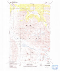
1951 Map of Mt. Katmai B-4
USGS Topo · Published 1993About this map
The Valley of Ten Thousand Smokes dominates this 1951 study of the Alaska Peninsula, showcasing the dramatic geological changes following the 1912 eruption. The volcanic landscape is defined by massive ash flows and the prominent vent of Novarupta, situated between Baked Mountain, Broken Mountain, and Falling Mountain. This map documents the complex glacial and fluvial systems of the Katmai National Park and Preserve, particularly where The Knife Creek Glaciers feed into Knife Creek. Towering summits like Mt Griggs and Mt Ikagluik provide significant elevation markers for the Katmai Wilderness, while the Buttress Range and Mt Cerberus frame the western edge of the valley. This survey captures a terrain essentially devoid of human infrastructure, focusing instead on the raw transition of a landscape reshaped by one of the largest volcanic events in recorded history.
Find a feature on this map
19 named features on this map. Tap any name to fly to it.
Don’t see what you’re looking for? This feature index may not catch every label — zoom into the map to look around manually.
Map Details
Editions of this 1951 Mt. Katmai B-4 Map
4 editions found
Other maps of this area

1948 · Mt Katmai
USGS Topo · 1:250,000

1951 · Mt Katmai
USGS Topo · 1:250,000

1951 · Mount Katmai A-3
USGS Topo · 1:63,360

1951 · Mount Katmai C-3
USGS Topo · 1:63,360

1951 · Mount Katmai B-4
USGS Topo · 1:63,360

1951 · Mount Katmai C-5
USGS Topo · 1:63,360

1951 · Mount Katmai C-4
USGS Topo · 1:63,360

1951 · Mount Katmai A-4
USGS Topo · 1:63,360

1951 · Mount Katmai B-3
USGS Topo · 1:63,360

1951 · Mount Katmai B-5
USGS Topo · 1:63,360