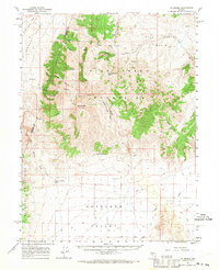
1961 Map of Mt. Moses
USGS Topo · Published 1970About this map
The Fish Creek Mountains dominate this central Nevada landscape, rising sharply between the expansive floor of Jersey Valley and the northern reaches of Antelope Valley. The prominence of Mt Moses serves as a geographic anchor, surrounded by a complex network of drainages including Butcher Canyon and Cedar Canyon. Human activity in the mid-twentieth century is marked by isolated infrastructure, such as the Radio Facility and several gravel pits, alongside a sparse collection of vital water sources like Hess Spring and Little Water Canyon. The map reveals a land defined by transit through high gaps and desert washes, with a prominent Jeep Trail crossing the Fish Creek Basin. The county line between Pershing Co and Lander Co bisects the western slopes, tracing a political boundary through the high terrain.
Find a feature on this map
29 named features on this map. Tap any name to fly to it.
Don’t see what you’re looking for? This feature index may not catch every label — zoom into the map to look around manually.
Map Details
Editions of this 1961 Mt. Moses Map
3 editions found

Other maps of this area

1932 · Sonoma Range
USGS Topo · 1:250,000

1939 · Sonoma Range
USGS Topo · 1:250,000

1955 · Millett
USGS Topo · 1:250,000

1955 · Winnemucca
USGS Topo · 1:250,000

1958 · Winnemucca
USGS Topo · 1:250,000

1959 · Millett
USGS Topo · 1:250,000

1961 · McCoy
USGS Topo · 1:62,500

1961 · Mt. Tobin
USGS Topo · 1:62,500

1961 · Cain Mountain
USGS Topo · 1:62,500

1961 · The Cedars
USGS Topo · 1:62,500