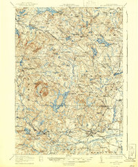
1919 Map of Mt. Pawtuckaway
USGS Topo · Published 1944About this map
Mount Pawtuckaway dominates the southern landscape of this Rockingham County region, providing a high vantage point over a network of small mill towns and agricultural settlements during the early twentieth century. The area is characterized by its numerous water bodies, including Bow Lake and Mendums Pond, which supported local industry and the developing village centers. The Boston and Maine Railroad cuts through the southern reaches, connecting hubs like Raymond and Epping via the Portsmouth Side and Manchester divisions.
Find a feature on this map
152 named features on this map. Tap any name to fly to it.
Don’t see what you’re looking for? This feature index may not catch every label — zoom into the map to look around manually.
Map Details
Editions of this 1919 Mt. Pawtuckaway Map
5 editions found

Other maps of this area

1888 · Newburyport
USGS Topo · 1:62,500

1888 · Haverhill
USGS Topo · 1:62,500

1890 · Haverhill
USGS Topo · 1:62,500

1890 · Newburyport
USGS Topo · 1:62,500

1891 · Berwick
USGS Topo · 1:62,500

1893 · Dover
USGS Topo · 1:62,500

1893 · Berwick
USGS Topo · 1:62,500

1893 · Haverhill
USGS Topo · 1:62,500

1894 · Newburyport
USGS Topo · 1:62,500

1905 · Manchester
USGS Topo · 1:62,500