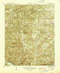
1942 Map of Mt Pleasant
USGS Topo · Published 1945About this map
Lafferty Creek winds through the heart of this Ozark landscape, connecting the high ridges of Pine Mtn to the southern boundary along the White River. During the early 1940s, this region of Izard County was defined by its scattered rural institutions and emerging industrial interests. The map documents numerous community centers such as the Macedonia Sch and Mt Lebanon Ch, alongside family-named sites like the Barren Fork Cem and Mosier Cem. Manganese mining activity is clearly visible near the southern border, where the Clubhouse Mine and Clubhouse Extension Mines appear near the settlement of Turner. The survey also marks the path of State Route 69 as it passes through the primary settlement of Mt Pleasant, providing a snapshot of the transportation network and topography before significant mid-century changes.
Find a feature on this map
47 named features on this map. Tap any name to fly to it.
Don’t see what you’re looking for? This feature index may not catch every label — zoom into the map to look around manually.
Map Details
Editions of this 1942 Mt Pleasant Map
5 editions found
Other maps of this area

1890 · Batesville
USGS Topo · 1:125,000

1891 · Batesville
USGS Topo · 1:125,000

1942 · Bethesda
USGS Topo · 1:24,000

1942 · Batesville
USGS Topo · 1:31,680

1942 · Mt Pleasant
USGS Topo · 1:31,680

1943 · Sandtown
USGS Topo · 1:24,000

1943 · Batesville
USGS Topo · 1:24,000

1951 · Melbourne
USGS Topo · 1:62,500

1953 · Memphis
USGS Topo · 1:250,000

1956 · Memphis
USGS Topo · 1:250,000