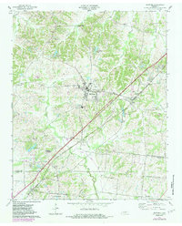
1971 Map of Munford
USGS Topo · Published 1983About this map
Munford and Atoka anchor this West Tennessee landscape during a period of steady growth along the Illinois Central Gulf rail corridor. The map reveals a dense network of rural community centers, often defined by local institutions like Campground Ch, Ellis Sch, and St Marks Ch. The topography is shaped by the many branches of Hurricane Creek and Big Bull Creek, which carve through the terrain between the Tipton and Shelby county line. Geographers and local historians can trace the transition from agricultural land to more developed spaces, noted by the presence of Edmond Orgill Park and various radio and lookout towers. Smaller, family-named locales like Hagys Corner, Akins Corner, and Simonton reflect the enduring settlement patterns of the mid-20th century before the era of intensive suburban expansion.
Find a feature on this map
50 named features on this map. Tap any name to fly to it.
Don’t see what you’re looking for? This feature index may not catch every label — zoom into the map to look around manually.
Map Details
Editions of this 1971 Munford Map
3 editions found
Other maps of this area

1942 · Millington
USGS Topo · 1:62,500

1954 · Mason
USGS Topo · 1:62,500

1956 · Blytheville
USGS Topo · 1:250,000

1959 · Blytheville
USGS Topo · 1:250,000

1960 · Millington
USGS Topo · 1:62,500

1961 · Rialto
USGS Topo · 1:62,500

1962 · Rialto
USGS Topo · 1:62,500

1963 · Osceola
USGS Topo · 1:62,500

1965 · Osceola
USGS Topo · 1:62,500

1965 · Brighton
USGS Topo · 1:24,000