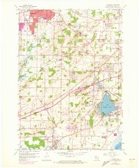
1959 Map of Muskego
USGS Topo · Published 1973About this map
Little Muskego Lake and the surrounding terrain of Waukesha County reveal a landscape of transition between suburban expansion and rural heritage. In the northern reaches, the city of Waukesha extends its grid near the Prairie Home Cemetery and multiple institutions including Whittier Sch and Echo Glen Sch. Moving south toward Muskego, the map preserves the mid-century character of small community hubs like Prospect and Big Bend along the Fox River. The 1971 photorevisions, indicated in purple, highlight the encroaching residential developments around Linnie Lac and the expanding road networks connecting these burgeoning towns. Scattered gravel pits and radio towers suggest a period of active local infrastructure building, while numerous country schools such as Mill Valley Sch and Lawnsdale Sch anchor the map's historical geography.
Find a feature on this map
52 named features on this map. Tap any name to fly to it.
Don’t see what you’re looking for? This feature index may not catch every label — zoom into the map to look around manually.
Map Details
Editions of this 1959 Muskego Map
4 editions found
Other maps of this area

1891 · Muskego
USGS Topo · 1:62,500

1892 · Waukesha
USGS Topo · 1:62,500

1892 · Oconomowoc
USGS Topo · 1:62,500

1892 · Eagle
USGS Topo · 1:62,500

1894 · Eagle
USGS Topo · 1:62,500

1897 · Eagle
USGS Topo · 1:62,500

1901 · Waukesha
USGS Topo · 1:62,500

1901 · Muskego
USGS Topo · 1:62,500

1906 · Eagle
USGS Topo · 1:62,500

1906 · Waukesha
USGS Topo · 1:62,500