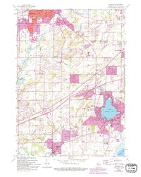
1959 Map of Muskego
USGS Topo · Published 1994About this map
Little Muskego Lake and the developing residential corridors between Waukesha and New Berlin define this mid-century portrait of southeastern Wisconsin. The landscape transition from the industrial outskirts of Waukesha to the small-town character of Muskego is evident in the dense network of rural schools and family cemeteries. Educational landmarks like Mill Valley Sch and parochial centers such as St Josephs Sch reflect a growing suburban population settling among older farming communities.
Find a feature on this map
58 named features on this map. Tap any name to fly to it.
Don’t see what you’re looking for? This feature index may not catch every label — zoom into the map to look around manually.
Map Details
Editions of this 1959 Muskego Map
4 editions found
Other maps of this area

1891 · Muskego
USGS Topo · 1:62,500

1892 · Waukesha
USGS Topo · 1:62,500

1892 · Oconomowoc
USGS Topo · 1:62,500

1892 · Eagle
USGS Topo · 1:62,500

1894 · Eagle
USGS Topo · 1:62,500

1897 · Eagle
USGS Topo · 1:62,500

1901 · Waukesha
USGS Topo · 1:62,500

1901 · Muskego
USGS Topo · 1:62,500

1906 · Eagle
USGS Topo · 1:62,500

1906 · Waukesha
USGS Topo · 1:62,500