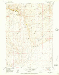
1952 Map of Muskrat Basin
USGS Topo · Published 1956About this map
Beaver Rim serves as the dominant topographical feature of this Wyoming landscape, dividing the high plateau from the lower reaches of Muskrat Basin. The map captures a transition point in the Missouri River Basin development program, illustrating a sparse and functional high-desert terrain. Local industry and early settlement traces are visible through specific landmarks like the Sherlock Shearing Pens and the site of Indian Grove, indicating the importance of livestock and seasonal work in this corner of Fremont County.
Find a feature on this map
13 named features on this map. Tap any name to fly to it.
Don’t see what you’re looking for? This feature index may not catch every label — zoom into the map to look around manually.
Map Details
Editions of this 1952 Muskrat Basin Map
4 editions found
Other maps of this area

1951 · Stampede Meadow
USGS Topo · 1:24,000

1951 · Black Rock Gap
USGS Topo · 1:24,000

1951 · Graham Ranch
USGS Topo · 1:24,000

1952 · Tin Cup Mountain
USGS Topo · 1:24,000

1952 · Muskrat Basin
USGS Topo · 1:24,000

1952 · Rongis Reservoir SE
USGS Topo · 1:24,000

1952 · Rongis Reservoir
USGS Topo · 1:24,000

1952 · Puddle Springs
USGS Topo · 1:24,000

1952 · Coyote Springs
USGS Topo · 1:24,000

1955 · Casper
USGS Topo · 1:250,000