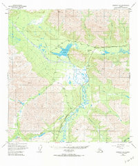
1949 Map of Nabesna D-6
USGS Topo · Published 1984About this map
Mentasta Lake and the settlement of Mentasta occupy a critical mountain corridor in the late 1940s, situated where the Glenn Highway traverses the landscape. This survey documents a transitional period for interior Alaska, where traditional routes like the Eagle Trail and various unnamed tractor trails represent the primary infrastructure alongside the newer highway. The Slana River snakes through the center of the sheet, fed by numerous tributaries such as Mentasta Creek and Mabel Creek. To the south, the terrain becomes increasingly complex around Indian Pass and Bear Valley. Evidence of mid-century frontier activity is visible near the Lodge and its adjacent Landing Strip, which served as vital connections for this remote subarctic region before more extensive modern development occurred.
Find a feature on this map
28 named features on this map. Tap any name to fly to it.
Don’t see what you’re looking for? This feature index may not catch every label — zoom into the map to look around manually.
Map Details
Editions of this 1949 Nabesna D-6 Map
5 editions found
Other maps of this area

1948 · Tanacross A-6
USGS Topo · 1:63,360

1948 · Nabesna C-6
USGS Topo · 1:63,360

1948 · Nabesna D-5
USGS Topo · 1:63,360

1948 · Tanacross A-5
USGS Topo · 1:63,360

1949 · Tanacross
USGS Topo · 1:250,000

1949 · Nabesna D-6
USGS Topo · 1:63,360

1949 · Tanacross A-5
USGS Topo · 1:63,360

1949 · Gulkana C-1
USGS Topo · 1:63,360

1949 · Mt. Hayes A-1
USGS Topo · 1:63,360

1950 · Tanacross
USGS Topo · 1:250,000