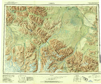
1950 Map of Nabesna
USGS Topo · Published 1954About this map
The Mentasta Mountains and Nutzotin Mountains dominate this 1950 topographical study, illustrating a landscape defined by glacial activity and remote Alaskan settlements. Small outposts such as Mentasta Village, Chisana, and Slana provide evidence of early habitation and resource extraction, while the Nabesna Road and Glenn Highway show the developing transportation corridors connecting these isolated hubs. The transition from the Tetlin Indian Reservation to the high peaks of the Wrangell Mountains is meticulously detailed, including massive ice features like the Nabesna Glacier and Copper Glacier. Aviation's critical role in the region is evident through the inclusion of Northway Landing Field, Reeve Field, and Chisana Landing Field, which served as vital links for trade and travel across the international boundary between the United States and Canada.
Find a feature on this map
62 named features on this map. Tap any name to fly to it.
Don’t see what you’re looking for? This feature index may not catch every label — zoom into the map to look around manually.
Map Details
Editions of this 1950 Nabesna Map
4 editions found

Other maps of this area

1948 · Tanacross A-6
USGS Topo · 1:63,360

1948 · Tanacross A-3
USGS Topo · 1:63,360

1948 · Tanacross A-4
USGS Topo · 1:63,360

1948 · Nabesna C-6
USGS Topo · 1:63,360

1948 · Nabesna D-5
USGS Topo · 1:63,360

1948 · Tanacross A-5
USGS Topo · 1:63,360

1949 · Tanacross
USGS Topo · 1:250,000

1949 · Nabesna D-6
USGS Topo · 1:63,360

1949 · Tanacross A-5
USGS Topo · 1:63,360

1949 · Gulkana C-1
USGS Topo · 1:63,360