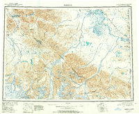
1950 Map of Nabesna
USGS Topo · Published 1957About this map
The Tetlin Indian Reservation and the sprawling drainages of the Nabesna River and Chisana River define this mid-century look at eastern Alaska. The landscape is marked by the meeting of the Mentasta Mountains, Nutzotin Mountains, and the Wrangell Mountains, creating a complex network of high passes and glacial runoff. Human presence is centered around native settlements like Mentasta Lake Village and Batzulnetas, alongside remote outposts such as Bonanza Chathenda and the mining-associated Chisana. The era’s transportation infrastructure is captured in the early routes of the Glenn Highway and the Alaska Highway, which provide rare corridors through the high terrain near the Alaska Yukon border. This survey also records localized landmarks like the Bear Cub Inn near Mentasta Pass and a Trading Post on the Tanana River system, illustrating the small, vital nodes of the northern interior economy.
Find a feature on this map
77 named features on this map. Tap any name to fly to it.
Don’t see what you’re looking for? This feature index may not catch every label — zoom into the map to look around manually.
Map Details
Editions of this 1950 Nabesna Map
4 editions found

Other maps of this area

1948 · Tanacross A-6
USGS Topo · 1:63,360

1948 · Tanacross A-3
USGS Topo · 1:63,360

1948 · Tanacross A-4
USGS Topo · 1:63,360

1948 · Nabesna C-6
USGS Topo · 1:63,360

1948 · Nabesna D-5
USGS Topo · 1:63,360

1948 · Tanacross A-5
USGS Topo · 1:63,360

1949 · Tanacross
USGS Topo · 1:250,000

1949 · Nabesna D-6
USGS Topo · 1:63,360

1949 · Tanacross A-5
USGS Topo · 1:63,360

1949 · Gulkana C-1
USGS Topo · 1:63,360