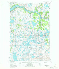
1952 Map of Naknek C-3
USGS Topo · Published 1972About this map
The Naknek River dominates this landscape, winding through a complex of tidal flats and points toward the Bristol Bay Borough coastline. On the southern bank, South Naknek stands opposite a Cannery at Coffee Pt, reflecting the area's deep-rooted fishing industry. The topography shows a transition from the river's Horseshoe Bend to an interior dense with small lakes and marshy terrain, navigated by a Winter Trail that cuts across the northern tundra. Several small settlements and seasonal sites like Savonoski, Kanaknoli, and Melokoshar line the river banks, illustrating the importance of waterway access for local movement. Toward the east, the burgeoning infrastructure of King Salmon is evident with Radio Towers and proximity to the confluence of King Salmon Creek, marking a shift toward more modern communications and transport hubs in this part of Alaska.
Find a feature on this map
29 named features on this map. Tap any name to fly to it.
Don’t see what you’re looking for? This feature index may not catch every label — zoom into the map to look around manually.
Map Details
Editions of this 1952 Naknek C-3 Map
3 editions found
Other maps of this area

1952 · Naknek
USGS Topo · 1:250,000

1952 · Naknek D-2
USGS Topo · 1:63,360

1952 · Naknek B-3
USGS Topo · 1:63,360

1952 · Naknek B-4
USGS Topo · 1:63,360

1952 · Naknek B-2
USGS Topo · 1:63,360

1952 · Naknek C-2
USGS Topo · 1:63,360

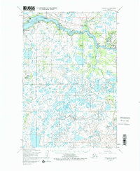
1952 · Naknek C-3
USGS Topo · 1:63,360

1952 · Naknek D-3
USGS Topo · 1:63,360

1952 · Naknek D-4
USGS Topo · 1:63,360

1952 · Naknek C-4
USGS Topo · 1:63,360