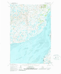
1952 Map of Naknek D-4
USGS Topo · Published 1981About this map
Kvichak River and the sweeping tidal expanses of Kvichak Bay dominate this coastal landscape at the head of Bristol Bay. The mapping reveals a sparse but vital network of early 1950s settlements, including the fishing stations and small outposts at Nakeen, Koggiung, and Libbyville. These locations, positioned along the shifting mud and sand of the Salmon Flats, reflect the seasonal salmon industry that has long defined the region's economy. Interior travel is represented by a Winter Trail that cuts through a terrain dense with unnamed lakes and small tributaries like Squaw Creek and Salmon Creek. One distinctive historical marker is a Saltery (Aband) located near Copenhagen Creek, providing a record of the ephemeral nature of early industrial sites in the Alaskan wilderness. Navigational features like Gravel Spit Anchorage and Telephone Pt offer insight into the maritime activity essential for connecting these isolated points.
Find a feature on this map
19 named features on this map. Tap any name to fly to it.
Don’t see what you’re looking for? This feature index may not catch every label — zoom into the map to look around manually.
Map Details
Editions of this 1952 Naknek D-4 Map
3 editions found
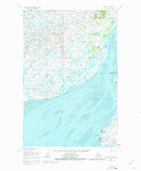
Other maps of this area

1951 · Dillingham
USGS Topo · 1:250,000

1952 · Naknek
USGS Topo · 1:250,000

1952 · Naknek C-5
USGS Topo · 1:63,360

1952 · Dillingham A-4
USGS Topo · 1:63,360

1952 · Naknek C-3
USGS Topo · 1:63,360

1952 · Naknek D-5
USGS Topo · 1:63,360

1952 · Dillingham A-3
USGS Topo · 1:63,360

1952 · Naknek D-3
USGS Topo · 1:63,360

1952 · Naknek D-4
USGS Topo · 1:63,360

1952 · Naknek C-4
USGS Topo · 1:63,360