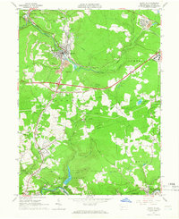
1964 Map of Nanty Glo
USGS Topo · Published 1966About this map
The borough of Nanty Glo serves as a focal point in this Cambria County landscape, where the Pennsylvania Railroad follows the winding path of Blacklick Creek. The mid-1960s terrain is heavily influenced by the local coal industry, marked by numerous Strip Mines and a large mine dump near the town center. To the north, the planned layout of Revloc sits near the headwaters of Williams Run, while the southern reaches are defined by the Little Conemaugh River passing through Ehrenfeld and Summerhill. Extensive utility infrastructure, including multiple pipelines and telephone lines, crisscrosses the hills between rural settlements like Vinco and New Germany. Significant local institutions are documented, from the Ebensburg State School on the eastern edge to the Ebensburg Airport, alongside numerous country churches such as Pike Ch and St Pauls Ch.
Find a feature on this map
52 named features on this map. Tap any name to fly to it.
Don’t see what you’re looking for? This feature index may not catch every label — zoom into the map to look around manually.
Map Details
Editions of this 1964 Nanty Glo Map
4 editions found
Other maps of this area

1902 · Ebensburg
USGS Topo · 1:62,500

1902 · Patton
USGS Topo · 1:62,500

1902 · Barnesboro
USGS Topo · 1:62,500

1904 · Barnesboro
USGS Topo · 1:62,500

1904 · Patton
USGS Topo · 1:62,500

1904 · Ebensburg
USGS Topo · 1:62,500

1904 · Johnstown
USGS Topo · 1:62,500

1907 · Johnstown
USGS Topo · 1:62,500

1943 · Punxsutawney
USGS Topo · 1:125,000

1953 · Pittsburgh
USGS Topo · 1:250,000