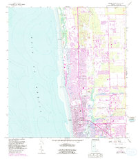
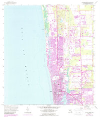
1958 Map of Naples North
USGS Topo · Published 1991About this map
Vanderbilt Beach and North Naples define the coastal character of this late-century photorevision, which documents the rapid transformation of the Southwest Florida shoreline. The intricate system of lagoons and inlets, including Inner Clam Bay, Venetian Bay, and Outer Doctors Bay, shows the extensive development of finger canals and waterfront properties characteristic of the era's land-use patterns.
Find a feature on this map
37 named features on this map. Tap any name to fly to it.
Don’t see what you’re looking for? This feature index may not catch every label — zoom into the map to look around manually.
Map Details
Editions of this 1958 Naples North Map
6 editions found
Other maps of this area

1956 · West Palm Beach
USGS Topo · 1:250,000

1957 · West Palm Beach
USGS Topo · 1:250,000

1958 · West Palm Beach
USGS Topo · 1:250,000

1958 · Bonita Springs
USGS Topo · 1:24,000

1958 · Belle Meade
USGS Topo · 1:24,000

1958 · Naples South
USGS Topo · 1:24,000

1958 · Belle Meade NW
USGS Topo · 1:24,000

1958 · Corkscrew SW
USGS Topo · 1:24,000

1958 · Naples North
USGS Topo · 1:24,000
1985 · Naples
USGS Topo · 1:100,000