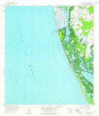
1958 Map of Naples South
USGS Topo · Published 1964About this map
Naples sits at the northern edge of this coastal survey, where the development of the mid-20th century meets the intricate mangrove systems of southwest Florida. The map illustrates a landscape defined by water and shifting sands, following the shoreline south from Naples Bay through the narrow opening at Gordon Pass. The terrain transitions into a complex network of tidal keys and inner waterways, including Dollar Bay and the wide expanse of Rookery Bay. These shallow estuaries and lagoons are separated from the open Gulf of Mexico by a thin, vulnerable barrier beach that terminates at Little Marco Pass. The survey records the early finger-canal developments in the town, showing the intersection of human engineering and the natural hydrological patterns of the Florida coast before decades of further expansion.
Find a feature on this map
10 named features on this map. Tap any name to fly to it.
Don’t see what you’re looking for? This feature index may not catch every label — zoom into the map to look around manually.
Map Details
Editions of this 1958 Naples South Map
5 editions found
Other maps of this area

1956 · Miami
USGS Topo · 1:250,000

1956 · West Palm Beach
USGS Topo · 1:250,000

1957 · West Palm Beach
USGS Topo · 1:250,000

1958 · West Palm Beach
USGS Topo · 1:250,000

1958 · Miami
USGS Topo · 1:250,000

1958 · Belle Meade
USGS Topo · 1:24,000

1958 · Naples South
USGS Topo · 1:24,000

1958 · Belle Meade NW
USGS Topo · 1:24,000

1958 · Naples North
USGS Topo · 1:24,000

1973 · Marco Island
USGS Topo · 1:24,000