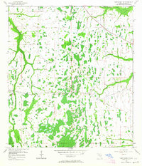
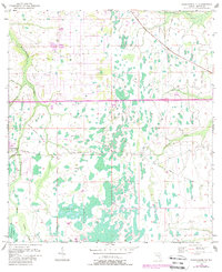
1953 Map of Narcoossee NE
USGS Topo · Published 1964About this map
The Econlockhatchee River and its companion, the Little Econlockhatchee River, dominate this landscape of central Florida, weaving through the expansive Econlockhatchee Swamp. This area in Orange County shows a region defined by water management and early transit, evidenced by the Disston Canal and the remnants of the Old Railroad Grade cutting across the terrain. Human presence is concentrated around Magnolia Ranch, which features a Lookout Tower and a nearby Gaging Station. The map captures a transition where natural drainage from features like Toxotohatchee Creek and Second Creek meets engineered solutions like the Spoil Bank. Scattered Windmills dot the interior, suggesting a reliance on groundwater for the ranching and agricultural operations that preceded the modern suburban expansion of the Orlando area.
Find a feature on this map
16 named features on this map. Tap any name to fly to it.
Don’t see what you’re looking for? This feature index may not catch every label — zoom into the map to look around manually.
Map Details
Editions of this 1953 Narcoossee NE Map
6 editions found
Other maps of this area

1953 · Narcoossee NE
USGS Topo · 1:24,000

1953 · Narcoossee SE
USGS Topo · 1:24,000

1953 · Narcoossee
USGS Topo · 1:24,000

1953 · Lake Poinsett SW
USGS Topo · 1:24,000

1953 · Titusville SW
USGS Topo · 1:24,000

1953 · Oviedo SW
USGS Topo · 1:24,000

1953 · Lake Poinsett NW
USGS Topo · 1:24,000

1953 · Narcoossee NW
USGS Topo · 1:24,000

1953 · Bithlo
USGS Topo · 1:24,000

1955 · Orlando
USGS Topo · 1:250,000