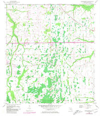
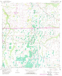
1953 Map of Narcoossee NE
USGS Topo · Published 1981About this map
Magnolia Ranch stands as a primary point of human activity in this largely aquatic landscape, where the Econlockhatchee River and its various tributaries define the terrain. The area is characterized by an intricate network of waterways, including the Little Econlockhatchee River, Tootoowahatchee Creek, and the extensive Eponlockhatchee Swamp. Modern infrastructure began to bisect this wilderness by the late 1970s, evidenced by the Bee Line Expressway (Toll Road) and a prominent Pipeline.
Find a feature on this map
19 named features on this map. Tap any name to fly to it.
Don’t see what you’re looking for? This feature index may not catch every label — zoom into the map to look around manually.
Map Details
Editions of this 1953 Narcoossee NE Map
6 editions found
Other maps of this area

1953 · Narcoossee NE
USGS Topo · 1:24,000

1953 · Narcoossee SE
USGS Topo · 1:24,000

1953 · Narcoossee
USGS Topo · 1:24,000

1953 · Lake Poinsett SW
USGS Topo · 1:24,000

1953 · Titusville SW
USGS Topo · 1:24,000

1953 · Oviedo SW
USGS Topo · 1:24,000

1953 · Lake Poinsett NW
USGS Topo · 1:24,000

1953 · Narcoossee NW
USGS Topo · 1:24,000

1953 · Bithlo
USGS Topo · 1:24,000

1955 · Orlando
USGS Topo · 1:250,000