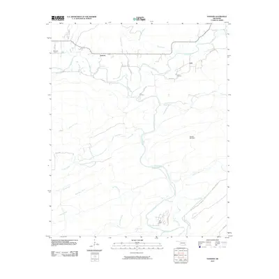
2010 Map of Nashoba
USGS Topo · Published 2010About this map
Nashoba and Nolia anchor this Pushmataha County landscape, where the meandering Little River and its numerous tributaries define the local geography. The map reveals a network of rural routes and family-named landmarks, such as Bob Johnson Loop and Fuller Rd, which connect scattered homesteads and ranches like the Little River Ranch. The terrain is characterized by the presence of Musket Mountain and a dense hydrological system including Black Fork, Jack Creek, and Cloudy Creek. Local history is preserved through sites such as Black Fork Cemetery and Nolia Cemetery, while the presence of Trails End Camp suggests the area's role in recreation. This survey captures a moment in the early 21st century before modern development significantly altered the rural character of this Oklahoma timber and ranching region.
Find a feature on this map
34 named features on this map. Tap any name to fly to it.
Don’t see what you’re looking for? This feature index may not catch every label — zoom into the map to look around manually.
Map Details
Editions of this 2010 Nashoba Map
This is the sole edition of this map. No revisions or reprints were ever made.
Other maps of this area

1901 · Tuskahoma
USGS Topo · 1:125,000

1901 · Alikchi
USGS Topo · 1:125,000

1908 · Tuskahoma
USGS Topo · 1:125,000

1909 · Tuskahoma
USGS Topo · 1:125,000

1950 · Mcalester
USGS Topo · 1:250,000

1962 · McAlester
USGS Topo · 1:250,000

1962 · Caney Mountain
USGS Topo · 1:24,000

1962 · Signal Mountain
USGS Topo · 1:24,000

1965 · McAlester
USGS Topo · 1:250,000
1971 · Albion SE
USGS Topo · 1:24,000