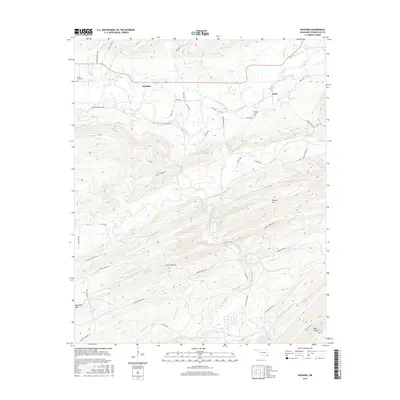
2016 Map of Nashoba
USGS Topo · Published 2016About this map
The Little River and Black Fork define the drainage and travel patterns of this Oklahoma territory, where the settlement of Nashoba sits at a crossroads of upland trails. An intricate network of local roads and paths, including the Cloudy Nashoba Trl and Bob Johnson Loop, connects the scattered residents of Pushmataha County. The landscape is characterized by prominent peaks such as Musket Mtn and Blackjack Mtn, which overlook a series of creeks including Jack Creek and Pickens Cr. For those researching local family history, the map identifies the Black Fork Cem and the Nolia Cem near the community of Nolia. These small settlements and their associated burial grounds provide essential touchstones for understanding the rural development of the region, while the trail systems like the Pickens Creek Trl indicate how the terrain was navigated before modern highway expansion.
Find a feature on this map
50 named features on this map. Tap any name to fly to it.
Don’t see what you’re looking for? This feature index may not catch every label — zoom into the map to look around manually.
Map Details
Editions of this 2016 Nashoba Map
This is the sole edition of this map. No revisions or reprints were ever made.
Other maps of this area

1901 · Tuskahoma
USGS Topo · 1:125,000

1901 · Alikchi
USGS Topo · 1:125,000

1908 · Tuskahoma
USGS Topo · 1:125,000

1909 · Tuskahoma
USGS Topo · 1:125,000

1950 · Mcalester
USGS Topo · 1:250,000

1962 · McAlester
USGS Topo · 1:250,000

1962 · Caney Mountain
USGS Topo · 1:24,000

1962 · Signal Mountain
USGS Topo · 1:24,000

1965 · McAlester
USGS Topo · 1:250,000
1971 · Albion SE
USGS Topo · 1:24,000