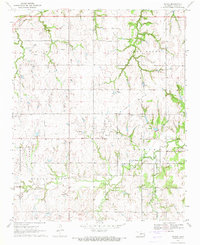
1970 Map of Navina
USGS Topo · Published 1971About this map
Navina sits at the center of this rural Logan County landscape, a crossroads community defined by its agricultural layout and drainage patterns at the start of the 1970s. The terrain is characterized by numerous winding waterways including Cottonwood Creek, Deer Creek, and Spring Creek, which have carved the rolling topography into distinct ridges like Iron Mound. This 1970 field-checked survey reveals the transition of local infrastructure, most notably the presence of an Old Railroad Grade and Old RR Grade running east-west through the center of the township, signaling the removal of tracks that once connected these rural outposts.
Find a feature on this map
22 named features on this map. Tap any name to fly to it.
Don’t see what you’re looking for? This feature index may not catch every label — zoom into the map to look around manually.
Map Details
Editions of this 1970 Navina Map
2 editions found
Other maps of this area

1892 · Guthrie
USGS Topo · 1:62,500

1892 · Edmond
USGS Topo · 1:62,500

1892 · Kingfisher
USGS Topo · 1:125,000

1895 · Kingfisher
USGS Topo · 1:125,000

1935 · Edmond
USGS Topo · 1:48,000

1940 · Edmond
USGS Topo · 1:62,500

1954 · Oklahoma City
USGS Topo · 1:250,000

1957 · Oklahoma City
USGS Topo · 1:250,000

1963 · Oklahoma City
USGS Topo · 1:250,000
1966 · Edmond
USGS Topo · 1:24,000