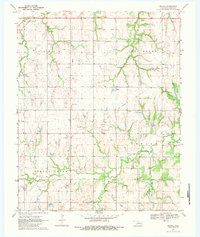
1970 Map of Navina
USGS Topo · Published 1983About this map
The small unincorporated community of Navina serves as the central point for this 1970 landscape, where the agricultural plains of Logan County are marked by an evolving energy economy. The southwestern portion of the map is dominated by the West Edmond Oil Field, indicated by numerous oil wells and a network of pipelines cutting across the sections. Transportation history is visible in the prominent Old Railroad Grade that angles through the territory, tracing a defunct rail corridor once vital to local transit.
Find a feature on this map
27 named features on this map. Tap any name to fly to it.
Don’t see what you’re looking for? This feature index may not catch every label — zoom into the map to look around manually.
Map Details
Editions of this 1970 Navina Map
2 editions found
Other maps of this area

1892 · Guthrie
USGS Topo · 1:62,500

1892 · Edmond
USGS Topo · 1:62,500

1892 · Kingfisher
USGS Topo · 1:125,000

1895 · Kingfisher
USGS Topo · 1:125,000

1935 · Edmond
USGS Topo · 1:48,000

1940 · Edmond
USGS Topo · 1:62,500

1954 · Oklahoma City
USGS Topo · 1:250,000

1957 · Oklahoma City
USGS Topo · 1:250,000

1963 · Oklahoma City
USGS Topo · 1:250,000
1966 · Edmond
USGS Topo · 1:24,000