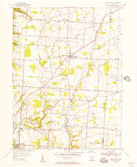
1955 Map of New Albany
USGS Topo · Published 1956About this map
New Albany and the rural townships of Plain and Jefferson appear here in the mid-1950s, characterized by a grid of farm roads and scattered country institutions. The map captures a landscape in transition as postwar development begins to reach beyond Gahanna and into the northeastern outskirts of the capital region. The eastern edge of the newly established Hoover Reservoir dominates the northwest corner, illustrating the large-scale infrastructure projects of the era. Settlement patterns follow the creek valleys, with clusters of family history found at St Paul Ch, Jersey Chapel, and several local burial grounds including Burnside Cem and Maplewood Cem. Significant wooded tracts remain at Blendon Woods Park, while the local economy is represented by Gravel Pits and traditional community centers like the Township Sch.
Find a feature on this map
41 named features on this map. Tap any name to fly to it.
Don’t see what you’re looking for? This feature index may not catch every label — zoom into the map to look around manually.
Map Details
Editions of this 1955 New Albany Map
This is the sole edition of this map. No revisions or reprints were ever made.
Other maps of this area

1902 · Westerville
USGS Topo · 1:62,500

1904 · Westerville
USGS Topo · 1:62,500

1907 · Thurston
USGS Topo · 1:62,500

1908 · Granville
USGS Topo · 1:62,500

1909 · Thurston
USGS Topo · 1:62,500

1910 · Granville
USGS Topo · 1:62,500

1925 · East Columbus
USGS Topo · 1:62,500

1943 · East Columbus
USGS Topo · 1:62,500

1947 · Columbus
USGS Topo · 1:250,000

1950 · Marion
USGS Topo · 1:250,000