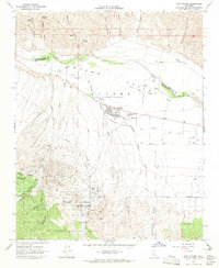
1964 Map of New Cuyama
USGS Topo · Published 1965About this map
The planned mid-century community of New Cuyama sits at the heart of the Cuyama Valley, serving as a centralized hub for the local ranching and petroleum operations during the 1960s. The town's layout is clearly defined, featuring the Cuyama Valley High Sch, Richardson Park, and a nearby Landing Strip. The landscape is dominated by the wide, arid course of the Cuyama River and a complex network of dry washes and canyons, including Salisbury Canyon Wash and Bitter Creek.
Find a feature on this map
41 named features on this map. Tap any name to fly to it.
Don’t see what you’re looking for? This feature index may not catch every label — zoom into the map to look around manually.
Map Details
Editions of this 1964 New Cuyama Map
3 editions found
Other maps of this area

1902 · Santa Ynez
USGS Topo · 1:125,000

1905 · Santa Ynez
USGS Topo · 1:125,000

1912 · McKittrick
USGS Topo · 1:125,000

1941 · Caliente Mountain
USGS Topo · 1:62,500

1941 · McPherson Peak
USGS Topo · 1:62,500

1942 · Caliente Mtn
USGS Topo · 1:62,500

1942 · East of Cuyama Ranch
USGS Topo · 1:24,000

1943 · McPherson Peak
USGS Topo · 1:62,500

1943 · Caliente Mtn.
USGS Topo · 1:62,500

1943 · Cuyama Ranch
USGS Topo · 1:31,680