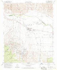
1964 Map of New Cuyama
USGS Topo · Published 1970About this map
New Cuyama sits at the heart of the Cuyama Valley, serving as a modern company-built hub along the Cuyama River during a period of significant petroleum development. The landscape is marked by the presence of numerous pipelines and several drill holes, illustrating the region's mid-century shift toward resource extraction. While the town itself features centralized planning with Richardson Park and Cuyama Valley High Sch, the surrounding terrain remains deeply defined by ranching history, evidenced by the large tract belonging to the (Heirs of Cesario Lataillade) and the historic Cuyama Ranch. To the south, the terrain rises into the Los Padres National Forest, where steep drainage networks like Salisbury Canyon and Branch Canyon create a sharp contrast to the flat valley floor, including recreational landmarks like the Branch Canyon Campground.
Find a feature on this map
40 named features on this map. Tap any name to fly to it.
Don’t see what you’re looking for? This feature index may not catch every label — zoom into the map to look around manually.
Map Details
Editions of this 1964 New Cuyama Map
3 editions found
Other maps of this area

1902 · Santa Ynez
USGS Topo · 1:125,000

1905 · Santa Ynez
USGS Topo · 1:125,000

1912 · McKittrick
USGS Topo · 1:125,000

1941 · Caliente Mountain
USGS Topo · 1:62,500

1941 · McPherson Peak
USGS Topo · 1:62,500

1942 · Caliente Mtn
USGS Topo · 1:62,500

1942 · East of Cuyama Ranch
USGS Topo · 1:24,000

1943 · McPherson Peak
USGS Topo · 1:62,500

1943 · Caliente Mtn.
USGS Topo · 1:62,500

1943 · Cuyama Ranch
USGS Topo · 1:31,680